The Altiplano is a depression between the powerful mountain ranges of the Western Cordillera and the Eastern Cordillera of the Central Andes in the west of the South American continent, a vast mountain plateau located in the states of Peru, Bolivia, Chile, and Argentina. It extends in an elongated long strip with a slight gradual gradient from northwest to southeast, from southern Peru to northern Argentina. Bolivia has the largest portion of the plateau.
Geography
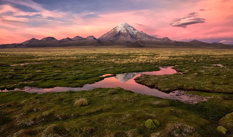
The Altiplano is the world’s second largest (after the Tibetan Plateau) high altitude plateau (about 100,000 km2), located in its main part at 3,300-3,800 m above sea level (For comparison, the Tibetan Plateau is on average 4,877 m high. ) On the Altiplano there is the highest navigable lake in the world, Lake Titicaca, which is also the second largest (surface area – 8300 km2, average depth 140-180 m, maximum depth of more than 281 m) lake of the continent, after Lake Maracaibo, which is sometimes qualified as a marine bay, and then Titicaca takes first place. And the largest salt marsh in the world, Uyuni, in addition to its size (area – 10,588 km2) and large salt reserves (about 10 billion tons), is famous for its mesmerizing, truly unique beauty of the landscape. In summer (the Altiplano belongs to the Southern Hemisphere), during the rainy season from December to February, a thick layer of salt, up to 8 m, is covered by a thin film of water, and Uyuni turns into a giant natural mirror, in which the sky of piercing blue and rare small clouds running over it are reflected.
The Altiplano was formed by the collision of the South American and Pacific plates in the Cenozoic (beginning 66 million years ago and ending 23.03 million years ago) and was formed in the Pleistocene about 10 million years ago as it is today. The Western Cordillera Range of the Central Andes adjoins the Altiplano from the west, with a volcanic zone that peaks over 6,000 m above sea level. Most of these volcanoes are dormant, but from time to time they emit sulfurous gases. To the east is the Eastern Cordillera. Its highest part is Cordillera Real, in which (in the northeast) are located volcanoes Iliampu (6368 m), Waina Potosi (6088 m), Ankouma (6427 m) and Illimani (6438 to 6462 m), covered by glaciers. Viewed from the Altiplano, the mountain ranges of both Cordilleras play the role of powerful walls shielding the plateau from the winds and cyclones of the Pacific and Atlantic oceans. The tectonic process, however, continues, and this can be observed visually near the borders of Bolivia with Chile and Argentina. There stretch chains of volcanic craters with boiling lava, surrounded by bubbling mud lakes and geysers.
The topography of the Altiplano is defined mainly by a series of depressions filled with sedimentary rocks washed away by rainfall from both Cordilleras. The eastern Cordillera is adjacent to the lowest part of the plateau, which is rocky and barren. More than 300 rivers flow into Titicaca from the glaciers of the Cordilleras surrounding the plateau, but only one, the Desaguadero, flows out. At the beginning of its course, this river is wide and navigable, and its water is fresh. Although the temperature of the water in the Desaguadero never exceeds +10° C, it evaporates intensely. The river inevitably becomes shallower, eroding the salt strata adjacent to its banks, and gradually becomes more and more salty, and as such it is the only river in the world. The Desaguadero flows into the inland saline Lake Poopo, whose area is variable, averaging about 1,340 km2. Lakes Titicaca and Poopo are derived from a huge water basin, referred to in historical geology as the Ballivian. Over time, Lake Minchin separated from it. These lakes were up to 100 m deep and about a million and a half years ago covered most of the plateau. The Uyuni and Koipasa solonchaks (about 3,680 m above sea level, area 2,218 km2) were formed on the site of Lake Minchin.
The climate of the Altiplano is characterized by sharp fluctuations in daily temperatures, from +30°C during the day to 0°C at night. There is little rainfall in the west of the plateau, a maximum of 150 mm per year, over Titicaca reaches 800 mm per year, in the south no more than 300 mm. The air over the plateau is very thin, and the sun here seems blindingly bright.
Nature
In its large extent, the highlands give the impression of being untouched by civilization. But there are other places on the Altiplano where life thrives.
Indeed, much of this high plateau is dry and therefore uninhabitable desert, blown by every wind. Mostly drought-resistant grasses and bushes grow here, and there are almost no trees except in the foothills, which, in fact, do not belong to the plateau. The fauna is represented by chinchillas, foxes, ungulates: llamas, alpacas, descended from miniature humpbacked camels vicuñas. The salt marshes are home to and breed significant colonies of three flamingo species – the Chilean, Andean and James flamingo. The largest population of these graceful birds with delicate pink plumage on the Altiplano is found on the shores of salt lake Laguna Colorado in the south, where the red-brown algae, a favorite of flamingos, is particularly abundant.
History
The Altiplano Plateau is inhabited primarily by the Aymara and Quechua Indians, whose ancestors came here about 10,000 years ago. It is thought that it was here, in what is now Peru and Bolivia, that they first discovered the virtues of the wild potato. This fateful event, without exaggeration, for the whole planet occurred about seven or nine thousand years ago. The Indians not only boiled and baked the nutritious tubers, but also worshipped the plant itself, believing it to be a gift from the gods. The potato was first introduced to Europeans by the Spanish priest and warrior Pedro Cieza de León, geographer and historian of the Spanish conquest of South America in 1551, and was confirmed as a biological plant by the French agronomist Antoine-Auguste Parmantier in the 18th century.
The most livable part of the plateau is located between Uyuni and Titicaca. In the times of the Inca Empire (11th-16th centuries) this land flourished and was called Kolasuyu. To the east of Lake Titicaca in even earlier, pre-Columbian times, as they say, there was a civilization of the city of Tiahuanaco. According to the archaeological data it was founded in 1500 B.C. In II-IX centuries. Tiwanaku was the largest city of the Central Andes and the capital of the state of Pukina, where lived about 40 thousand people and around which existed perfect for its time ramified irrigation structures. Around 1180 the inhabitants of Tiwanaku abandoned the city after it was overrun by the Aymara (Stake) Indians. The Incas believed that their first paramount ruler, Manco Capac, was from Tiwanaku.
The name Altiplano, which in Spanish means simply High Plain, was given to it by the conquistadors in the middle of the 16th century. But there was so much silver and so pure that, according to the accounts of the time, the Spanish Mint worked only on it. Especially a lot of silver, as well as tin, was mined on Mount Potosí (4,748 m) in Bolivia, whose local Spanish name was Sierra Rico (Rich Mountain), the Indian name was Putun-Si (Birth or Giving Mountain). According to official statistics, from 1556 to 1783 the mines of Potosí produced 45 thousand tons of pure silver, which was exactly half of all silver production in the world. Now silver in Potosi is mined only by small private groups of miners: it is almost gone. But as for the Altiplano plateau as a whole, it is still a mining site for silver as well as other precious metals. Uyuni has enormous reserves of lithium chloride. Large deposits of oil and natural gas have been explored and are beginning to be exploited in the lowlands of the plateau. Bolivia’s main hopes and plans for the country’s economic development are tied to these natural resources.
General Information
- The western part of the inner plateau of the Central Andes.
- The largest city is La Paz (Bolivia) with a population of 887,512 (2009).
- Other cities: Puno, Oruro, Potosí, Cuzco.
- Currency: Bolivian Bolivano, Peruvian New Salt, Chilean peso, Argentine peso.
- Languages: Spanish is the official language, and 36 local languages are in use.
- Ethnic composition: indigenous nationalities, in the cities – descendants of white immigrants from Spain.
- River: Desaguadero.
- Nearest airport: El Alto, La Paz (international).
- Area: about 100,000 km2.
- Length: 809 to 965 km.
- Maximum width: 129 km.
- Average height above sea level: 3,650 m.
- Highest point near the plateau: Volcano Ilyimani (6,462 m) in the volcanic belt of the Eastern Cordillera.
Climate and weather
- High altitude, sharply continental.
- The average annual temperature is from +6°C to +12°C.
- The average annual rainfall ranges from 150 mm in the west to 800 mm in the north.
Economy
- Minerals: deposits of lithium, silver, tin, lead, zinc, tungsten, copper, oil, natural gas, table salt.
- Mining and ore mining and processing industries.
- Agriculture: breeding llamas and alpacas, using them as pack animals. Near Lake Titicaca – growing maize and wheat.
- Services: tourism.
Attractions
- Lake Titicaca.
- Lake Poopo.
- Uyuni salt marsh.
- Laguna Colorado Lake.
- City of Potosí: “barrios mitayos,” mining villages, a UNESCO World Heritage Site, and Spanish Baroque colonial architecture: public buildings, residences, 36 churches, most of which are now museums.
- Ruins of Tiwanaku.
- The national parks of Lauca, Isluga, Copaquilla, Zapahuira, Pan de Azúcar, Los Flamencos, Nevado de los Cruces, and the Eduardo Avaroa Reserve.
- “Cemetery of steam locomotives”, 3 km from the town of Uyuni (steam locomotives produced before the mid-1950s, left after the mining of some mines in the Altiplano).
Fun Facts
- Bolivia by its ethnic composition is “the most “Indian” country in Latin America. Most of its indigenous population lives on the Altiplano.
- The Uyuni solonchak, due to its large area and perfectly flat reflective surface when covered by a layer of water, the absence of clouds over it most of the year and the thin atmosphere is used in space technology as a natural tool, ideal for testing and tuning optical devices on orbiting Earth satellites.
- Native alpaca wool is fluffy, soft, and perfectly warm. It is considered the highest quality wool in the world and is used to make various products under the Altiplano brand.
- Lake Titicaca has 36 islands, two of them, the Moon Island and the Sun Island, are considered sacred by the local Indians.
- In the city of El Alto in Bolivia, on lampposts you can find human-sized dolls with a sign around their necks: “The thief will be executed on the spot. Of course, there is officially no lynch court in the country, but it’s not worth trying to check whether this is true or not in reality, the Aymara Indians are harsh and keep their word firmly. By the way, they strongly dislike being called Indians.
- Near the Uyuni salt marsh, there is the outlandish Luna Salada Hotel.
Not only the walls, but also the floor, the ceiling, and the furniture in the rooms are made of blocks of salt mined in Uyuni. Staying in such rooms has beneficial effects on respiratory organs, vessels and joints of human body. That is, you can be treated here, but it is important to know your individual measure, and, going to this or any other similar hotel, it is necessary to get a doctor’s recommendation. - A small Bolivian town Oruro, which takes its name from the Indian people Uru, is famous throughout Latin America for its carnival Diablada – “Deviliada”, held during the last week before Lent. The carnival lasts for three days and three nights, with at least 20 hours of main action. Originally, this mystery festival was dedicated to Pachamama, Mother Earth, and the god of the mountains, who was called Tio Supai, lord of the dark forces. In the seventeenth century these “wild orgies” were given a more pious appearance at the demand of the Spaniards. In 1789 a fresco of the Virgin Mary was found in one of the silver mines of Oruro, and the carnival began to be dedicated to the Virgin of Candelaria, or the Virgin of the Mine. Since then, the carnival has played out two mystery stories – about the history of the conquest and about the victory of the Archangel Michael over the devil. And alongside them the folk element rages: dancing to the friendly singing of the town’s inhabitants in grotesque costumes depicting human vices. In 2001, UNESCO declared this carnival “the oral-visual heritage of mankind.
- Legend has it that the Inca calendar records the amount of time it takes to boil potatoes. It was about one hour.


