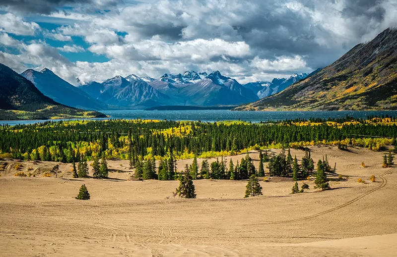
The Yukon Territory is one of Canada’s territories. It is located in the northwest of the country and borders Alaska (USA) to the west and other Canadian territories: the Northwest Territories to the east and British Columbia to the south. The Yukon has an area of about 482 thousand square kilometers.
This region of Canada gets its name from the Yukon River. In turn, the Yukon means “Great River” in the Gwich’in language of the Athabascan Indians.
Geography
The territory of the Yukon occupies the eastern part of the plateau of the same name, which in Canada is called the Canadian Cordilleras. The total area of the Yukon is 4.8% of the total area of Canada. The southern part of the Yukon is covered with large, elongated and narrow lakes fed by glaciers. One of the largest, Lake Atlin, is on the border with the province of British Columbia, and its name means “Big Water” in the Tlingit Indian language.
The territory’s main river, the Yukon, is the fifth largest in North America and the second largest in Canada (3185 kilometers).
The Yukon’s highest point, Mount Logan (5,959 meters), rises in the southwest, on the lands of Kluane National Park, a UNESCO World Heritage Site. The Yukon has two other national parks, Ayvavik and Wuntut, both in the north.
Here, a subarctic climate reigns supreme throughout the area, with long polar nights and extremely cold temperatures dropping to -50°C.
The Yukon lies within two large natural zones: taiga and tundra. The vegetation of the northern taiga forests is represented by white spruce, balsam poplar and birch, which grow mainly in the middle and southern part of the Yukon, in the subarctic zone. Most of the Yukon is occupied by the Arctic zone, where tundra vegetation predominates.
History
The central and northern part of the Yukon was settled by Native American tribes many centuries before Europeans arrived here. The reason is that this part of Canada escaped glaciation at the time when it was part of Beringia: the territories of present-day Chukotka and Alaska, connected by an isthmus 10,000 years ago, after which a strait, later called the Bering Strait, was formed here.
The first settlements of Indians appeared in the Yukon 10-20 thousand years ago. Gradually the Indians moved deep into America along the Yukon River valley.
Due to the inaccessibility of the territory, Europeans appeared here only in the XIX century, when intensive fur trade began and missionary activity revived. Europeans were greatly helped by the fact that the coastal and Indian tribes living in the interior of the continent already had their own developed trade routes.
Until 1870, the lands that are now the Yukon Territory were controlled by the Hudson’s Bay Company, which conducted exchange trade with the Indians.
But the greatest revitalization of the area began in the late 19th century, during the famous Klondike Gold Rush. It started in 1897 and was relatively peaceful compared to similar ones in California or Australia.
In the first weeks of the gold rush in the Yukon, the tiny fishing village of Dawson turned into a mining center with a population of 40,000 people. The total population of the Yukon increased so much in just one year that it led to the separation of Yukon County from the Northwest Territories and the formation of the separate Yukon Territory in 1898.
At that time other minerals were also found in the Yukon – silver, lead, zinc, and copper. Therefore, even after the end of the gold rush in 1899, the Yukon economy continued to grow. Currently, the capital of the Yukon Territory, Whitehorse, is the main center for the development of mineral resources of the region.
The lands of the Yukon are practically deserted. Winters are long and harsh. Nevertheless, people have lived in these lands for a long time and do not intend to leave them.
Population
The indigenous people, or First Peoples, Eskimos and Indians, have settled throughout the territory, from the Cordillera Mountains to the coast of the Arctic Ocean. They have lived here for thousands of years, trapping sea animals and fish and hunting.
The Yukon is home to many wild animals. Significant populations of grizzly bear, Arctic wolf, thin-horned sheep, Dall’s sheep, musk ox, and American moose remain here. The local herd of caribou is one of the largest in the north, numbering up to 130,000 animals.
The rivers and lakes of the Yukon are home to large schools of fish, mainly salmon, trout, grayling and whitefish.
The fur trade, once very developed, now plays a very minor role in the Yukon economy. Logging has not been developed.
Although the Yukon is almost entirely forested, the trees grow small due to the dry, cold climate and wind.
Mining remains the mainstay of the economy of this northern Canadian territory, accounting for more than 30% of the Yukon Territory’s total gross product. Despite the cold and polar night, several large mines are operating here: lead-zinc and gold-silver mines.
The second most lucrative industry in the Yukon Territory is tourism. Visitors come here to see the untouched nature of the Yukon, to fish on the northern rivers and lakes.
But the main attractions here are everything that is in one way or another connected with the short, but significant for the history of the Yukon gold rush period. The basis and center of such tourism is Dawson. The town looks as if the days of the prospectors who left here for the long and grueling search for gold.
The motto of the new Yukon is “Larger than life”. In this way the locals want to emphasize that to visit the Yukon is to experience an unforgettable, incomparable experience. Canoeing and kayaking, mountaineering and skiing, glacier conquering and dog sled racing, the opportunity to admire the flashes of the aurora borealis – this is not all that a visitor to the Yukon can get nowadays.
Today, 75% of the Yukon’s population is concentrated in the administrative center of the territory, the town of Whitehorse. The town’s name comes from the nickname given by the Indians to the rapids on the Yukon River: they looked very much like the waving manes of white horses. The rapids were located south of the town, in the rugged Mile Canyon, and presented a serious obstacle when traveling down the river. By now there is nothing left of them and they have been completely covered by water. In the last century the Yukon River was dammed upstream from Whitehorse.
Native Yukoners prefer to live in small villages or travel throughout the territory. Indians and Eskimos make up barely one-fourth of the Yukon’s population.
General Information
- Location: northern North America, northwestern Arctic part of Canada.
- Administrative center: Whitehorse 23,276 inhabitants (2011).
- Languages: English (85.69%), French (3.69%), German (2.59%), local languages (2006).
- Ethnic composition: English 27.1%, Indians and Eskimos 22.3%, Scots 21.9%, Irish 19.1%, Germans, French and others 9.6% (2001).
- Religions: Catholicism, Anglicans, United Church of Canada.
- Currency: Canadian dollar.
- Major population centers: Whitehorse, Dawson, Watson Lake, Carmacks, Faro, Mayo.
- Major rivers: Yukon, Porcupine, Teslin, McMillan.
- Major lakes: Mayo, Atlin, Clwain, Teslin, Frances, Bennett, Tagish, Marsh, Laberge, Kasawa.
- Area: 482,443 km2. The smallest of Canada’s federal territories.
- Population: 35,175 (2011) (0.1% of Canada’s total population).
- Population density: 0.07 people/km2.
- Highest point: Mount Logan (5959 m).
Economy
- Minerals: zinc and lead (Pine Point), gold, silver and uranium (Yellowknife), tungsten and copper (Tangsten), oil and natural gas (Norman Wells), diamonds (Las de Gras).
- Industry: mining.
- Hydropower.
- Hunting (fur trade).
- Forestry.
- Fishing.
- Reindeer breeding.
- Goods of folk crafts.
- Service sector: tourism.
Climate and weather
- Subarctic. Winters are comparatively long and severe, summer warm periods are short.
- Average temperature in January: -20°С.
- Average temperature in July: +14°C
- Average annual precipitation: 270 mm.
Attractions
- Whitehorse Town: McBride Museum, Miles Canyon.
- Dawson City: Jack London’s cabin, gold rush sights
- Yukon River
- Mount Logan (second highest mountain in North America after McKinley (6194 m))
- Lake Atlin
- Carcross Desert
- National Parks: Kluane, Ayvavik, Wuntut.
- Bonanza Creek (prospecting areas)
Fun Facts
- Despite the harsh natural and climatic conditions, all communities in the Yukon have broadband Internet access.
- In Canada, the term “redskins” is considered outdated and is not used much anymore. Instead, Canadians prefer to call Indians “First Peoples,” but it is not applied to Eskimos and Métis. The Indians themselves insist on being called by the names of their peoples.
- Snow cover in the town of Whitehorse reaches 145 centimeters per year.
- During World War II, the northern route of lend-lease – supplies of arms and food to the USSR from the USA and Canada – passed through the Yukon.
- The Klondike gold rush began on August 17, 1896, when gold was found on Bonanza Creek, which flows into the Klondike River. Most of the gold was mined in scattered form with a shovel and a trough. Those who attempted to mine the gold veins had to thaw the frozen ground with fires.
- In 1991, the population of the Yukon returned to its gold rush days, totaling 27,797.
- The remains of the site of primitive man near the settlement of Old Crow (in the Bluefish Caves) are the oldest traces of primitive people in America, they date back to 25-40 thousand years ago.
- Every year on July 1, a gold mining competition is held in Dawson. Participants are loaned wash trays and some of them manage to pan for a few dollars worth of gold.


