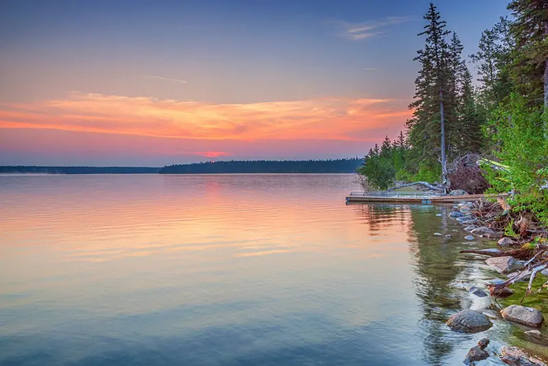
Lake Winnipeg is located in temperate latitudes, in the continental climate zone. In summertime, despite the low water temperature, the shores of the lake are full of vacationers who come here to swim and sunbathe. Winter is harsh: the lake is covered with ice for almost six months of the year.
Winnipeg is a favorite vacation spot for Canadians who come here to ride on steamboats and catch fish – Winnipeg yelloweye.
The largest lake in southern Canada
Lake Winnipeg is the largest lake in southern Canada, set amidst a forested wetland. Visibly elongated from north to south, Lake Winnipeg is a remnant of the once vast freshwater glacial Lake Agassiz, which existed some 10,000 to 12,000 years ago at the edge of a retreating ice sheet in North America.
As a result of glacier movement, Lake Winnipeg has a complex configuration, especially the western shore.
Many rivers flow into the lake, most of which are short in length. The shores of the lake are predominantly sandy, and there are large limestone cliffs with caves inhabited by countless bats, which have become a local landmark. Along the shores of the lake there are virgin taiga forests, especially on the eastern side. There are several hundred islands on the lake, mostly small and uninhabited. The three largest islands – Hecla, Deer and Black – are part of the Hecla/Grindstone Provincial Park. There are a total of six provincial parks, including Beaver Creek, Camp Morton, Winnipeg Beach, Elk Island and Grand Beach. To preserve the natural complex of Lake Winnipeg, two preserves have been established along its shores – Poplar-Nanovin Rivers on the eastern shore and Fisher Bay in the central part of the lake.
The lake is connected to Hudson Bay by the navigable Nelson River. It is an important lake shipping and commercial fishing area: the largest fishing port is Gimli. Recreational fishing on the lake has become a major tourist industry in the province of Manitoba. Pikeperch, northern pike, lake sturgeon, and yellow perch are caught here.
Lake Winnipeg became the basis for a reservoir of the same name, formed by the Jenpeg Dam (1990s) and a cascade of hydroelectric power plants built on the Nelson River that flows out of it, to generate electricity, regulate lake levels, improve navigation, irrigation and flood control in the northern parts of the province of Manitoba.
The Nelson River draws a very large amount of water from Lake Winnipeg, averaging 2,066 m3/sec, and forms part of the Hudson Bay water basin. This area is in the heart of the historic Rupert’s Land area, which was the property of the Hudson Bay Company, founded in 1670 and dedicated to exploiting the natural resources of this area of Canada.
History
The name of the lake is either from the language of the Cree Indian tribe (meaning “muddy waters”) or is a hydronym from the name of the Winnebago Indian tribe of the Sioux Indian Tribe.
It is generally believed that the first European to arrive on the shores of Lake Winnipeg was the English fur trader Henry Kelsey (circa 1667-1724). Also called Boy Kelsey, he was a noted tracker, buffalo hunter, and adventurer who played a significant role in the establishment of the Hudson’s Bay Company. Kelsey came up the Nelson River to the lake region ahead of the French, who were competing with him in the exchange trade with the Indians, and found himself at the heart of the Indian tribal warfare. Kelsey was able to inspire the Indians with his courtesy and became the most successful fur trader of the time, although the French tried to expel him from Canada on several occasions.
In the early 18th century, an expedition of French officer Pierre Gautier de Varennes (La Verendrye) (1685-1749) visited the shores of the lake, whose merit was the construction of the first fortifications – forts. It is La Verendrye to whom France owes the fact that the expanses of Western and Central Canada were explored, and the land itself was annexed to the colony of New France. La Verendrye’s expedition was financed by wealthy Quebec merchants who hoped to profit from the fur trade by diverting the flow of furs from the British from Hudson Bay. Because the expedition was poorly supplied, it was nearly derailed when La Verendrye found himself stranded on ice-bound Lake Winnipeg in winter with no hope of rescue.
Today, the shores of the lake are still as sparsely populated as they were in La Verendrye’s time, with just over 23,000 residents living in 30 small coastal communities, including Indian settlements representing Canada’s 11 indigenous tribes. The population increases many times during the summer when vacationers arrive on the shores of Lake Winnipeg.
There are no major cities on the lake. The city of Winnipeg, the capital of the Canadian province of Manitoba, is 64 kilometers away from the shore. And the largest settlement on the coast is Gimli (about 6000 people) – the center of the New Iceland area on the western shore of the lake. This town was built especially for the settlers from Iceland who left their island between 1870 and 1915. Almost 20,000 Icelanders settled on the shores at that time, attracted by the abundance of fish in the lake. Icelanders still live here today, are Canadian citizens, hold national festivals such as Islendingidagurinn, and publish their own newspaper in Icelandic.
Residents and tourists have to be extremely careful, as Lake Winnipeg is known for its unpredictable nature. Firstly, unusual phenomena are formed here, when at the northern wind at the southern shore of the waves suddenly grow up to 1 meter and higher, which is called “seishi waves”. Secondly, on the same southern shore, the depths in the same place can change with astonishing speed within just a few days. Third, the lake is characterized by sudden storms causing flooding and coastal erosion.
In addition, there has recently been an increase in algae, caused by the ingress of significant amounts of phosphorus into the water from industrial effluents and cultivated fields. And the very content of phosphorus in the water is becoming dangerous for humans.
However, the lake does not lose its popularity among lovers of beach recreation and fishing. Local residents have even turned it into a venue for major sporting events: World Windsurfing Competition (1994) and the Pan American Games (1999).
Thanks to its elongated shape, Lake Winnipeg became a major transportation route for the province of Manitoba – long before the railroad was built into the area. Today, in addition to traditional canoes, the lake’s waters are navigated by several old-fashioned steamboats. During the winter season, when the ice on the lake is thick enough, the steamboats are replaced by heavy trucks that travel along the ice road.
General Information
- Location: North America.
- Administration: Canada, province of Manitoba.
- Feeding method: mainly snowmelt.
- Outflowing rivers: Saskatchewan, Red River, Winnipeg, Bloodwine, Poplar, Behrens, Manigotagan, Dauphin, Fisher.
- Outflowing River: Nelson.
- Major islands: Hecla, Deer, and Black.
- Population centers: Gimli – 5,845 residents (2011), Pine Falls – 1,314 residents (2011), Winnipeg Beach – 1,017 residents (2006), Victoria Beach – 450 residents (2011), Grand Rapids – 239 residents (2011), Manigotagan – 191 residents (2006), Behrens River – 153 residents (2006).
- Most important airport: Winnipeg James Armstrong Richardson International Airport.
- Area: 24,387 km2 (5th largest freshwater lake in Canada, 12th largest freshwater lake in the world).
- Watershed area: about 984,200 km2 (including the Canadian provinces of Alberta, Saskatchewan, Manitoba, Ontario, and the U.S. states of Minnesota and North Dakota).
- Volume: 284 km3.
- Length: 425 km.
- Width: up to 109 km.
- Average depth: 12 m.
- Maximum depth: 36 m.
- Multiyear amplitude of level fluctuations: about 3 m.
- Coastline length: 1,750 km.
Climate and weather
- Continental.
- Long and cold winters.
- Average temperature in January: -18°C.
- Average temperature in July: +20°C.
- Average annual precipitation: 500 mm.
- Relative humidity: 80%.
- Ice break-up: from November to the end of April.
Economy
- Minerals: gold, silver, oil, copper, zinc, natural gas.
- Hydroelectric power (hydroelectric power station cascade on the Nelson River, Grand Rapids hydroelectric power station on the Saskatchewan River).
- Industry: shipbuilding, woodworking, pulp-and-paper, food industry.
- Agriculture: crop production (corn, wheat).
- River navigation.
- Fishing and fish breeding.
- Irrigation and water supply.
- Service sector: tourism (recreational fishing, surfing).
Attractions
- Natural: Nelson and Saskatchewan Rivers of North America; Hecla, Deer and Black Islands; Hecla/Grindstone, Beaver Creek, Camp Morton, Winnipeg Beach, Elk Island and Grand Beach Provincial Parks; Poplar-Nanowin Rivers and Fisher Bay Nature Preserves; waterfalls: Pointe de Bois, Slave, Seven Sisters, MacArthur, Pine and Great Falls.
- Architectural: Jenpeg Dam on the Nelson River.
- City of Winnipeg: Old Town, Forks Historic District (trading place with Indians), Victorian homes in the Eskchange neighborhood, Concert Hall, Fort Garry, 11-story Confederation Building, Manitoba Provincial Museum, Winnipeg Art Gallery, St. Boniface Museum (history of Winnipeg’s French community), Assiniboine Park and Winnie the Pooh Monument, Stoney Mountain Resort.
- Gimli Town: New Iceland attractions and folk festivals.
Fun Facts
- In 2010-2011, the total value of the Lake Winnipeg fish catch was $16,259,317.
- Lake Winnipeg was the filming location for the Hollywood blockbuster movie K-19 (Germany – Canada – UK, 2002) starring Harrison Ford.
- Several major rivers flow into Lake Winnipeg. The Winnipeg, Saskatchewan and Red River rivers carry more than 60% of the river water into it.
- The water in Lake Winnipeg changes completely over a period of 3 to 5 years. This is a very short period of time compared to other large Canadian lakes: in Lake Superior, the water changes completely over a period of 191 years.
- Lake Winnipeg and the town of Winnipeg Beach were the setting for the 2006-2007 Canadian television series “Falcon Beach,” about the water changes over a period of 191 years. “Falcon Beach” about the glamorous life of a high society resort. The series is unique in that two versions were filmed simultaneously: one for Canadian viewers with Canadian place names and local features, and the other for American television audiences with American names and realities.
- On the shores of Lake Winnipeg lives the largest group of Icelanders outside of their historical homeland, the island of Iceland. There are currently about 26,000 of them, representing 2% of the total population of the province of Manitoba and 35% of all Canadian-Icelanders.
- The ancient glacial Lake Agassiz was larger than all of the modern Great Lakes until it was drained by the Nelson River, which channeled into Hudson Bay. In addition to Lake Winnipeg, several other lakes were formed at the site of Lake Agassiz, the most famous being Lake Manitoba, Lake Winnipegosis, Lake Nipigon, and Lake of the Woods.
- The hydroelectric cascade on the Nelson River has 13 hydroelectric power plants.
- New Iceland has never been a separate administrative unit, but the Canadian government has always allowed immigrants to retain their culture and language.
- The Cree Indians called the lake “Vinipek” – muddy waters.