The long and eventful life of the Vistula River began at the very beginning of the modern stage of the Earth’s history (the geological Quaternary Period, or Anthropogenic Period), when the climate cooled markedly. Over the last two million years, glaciation has covered the territory of present-day Poland eight times. Glaciers slid down from Scandinavia, each time having a strong influence on the formation of the river valley. In periods of warming, the ice receded and the Vistula valley became wider and deeper. The river took its present shape at least 14 thousand years ago, when the Scandinavian glaciation left the surrounding area. At present, the formation of the Vistula valley continues, as evidenced by the noticeable erosion of its banks and the accumulation of river sediments along the entire riverbed.
The main peculiarity and difference of the Vistula basin from other European rivers is its asymmetry as a consequence of glacier movement: the right part of the basin accounts for 73% and the left part for 27% of the area.
The largest river in Poland
The Vistula is the longest river in Poland and is located in the center of Europe. Along the course of the river there are three types of relief: the plains of Eastern Europe, the uplands of Western Europe and the Alpine and Carpathian highlands.
The sources of the Vistula are located in the Carpathians, at an altitude of 1,220 m above sea level, on the western slope of the Barania Góra in the Moravian-Silesian Beskid (Western Carpathians), in the extreme south of Poland. Barania Góra is the second highest mountain in the Moravian-Silesian Beskid, the highest in the Polish part of the Upper Silesia historical and geographical region and one of the most important tourist attractions in southern Poland: its summit offers a wonderful view of the surrounding countryside.
The Vistula River is formed by the confluence of two rivers: the White Wiselka (the main source) and the Black Wiselka.
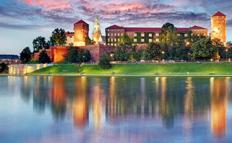
The upper course of the Vistula, in the mountains, is very turbulent. Descending to the plain and reaching Krakow, the ancient royal capital of Poland, the Vistula takes several Carpathian tributaries, becomes full-flowing, its flow slows down.
The Vistula in its middle and lower reaches is a classic plain river, carrying its waters within a wide terraced valley. It often bends, forming many shoals, which makes navigation difficult. Therefore, from the city of Toruń to the mouth, the Vistula’s course is regulated and its banks are reinforced to avoid landslides.
In spring the river is fed by melt water, floods are frequent, the water level can rise up to 10 meters, which causes catastrophic floods and ice jams. Floods are followed by shoaling, which hinders navigation.
The Vistula’s regime is very capricious and depends on the weather conditions in the basin of both the Vistula itself and its Carpathian tributaries. Apart from the spring floods, particularly severe floods are observed in June and September, when there is a lot of rain in the Carpathians.
The Vistula flows into the Gulf of Gdańsk of the Baltic Sea, 15 km east of the city of Gdańsk. Already 50 km from the sea, the Vistula splits into separate branches: the right – Nogat left – Lenivka, Dead Vistula and others. The arms of the Vistula form a wide delta called Żulawy. In this place the Vistula leaves a large amount of river sediment and forms sand dunes separating the Żulawy from the Baltic Sea. Since a significant part of the Żuławy is located 2 meters below sea level, a network of dikes and drainage canals had to be built in this place. The network of canals is one of the densest in Europe, with a total length of 17 thousand kilometers. The local soil is characterized by fertility, and Žulava is an area of intensive agriculture. Crop farming (wheat, sugar beet) prevails in the south of Žulava, dairy farming in the north and east, and vegetable farming in the northwest.
History
The Vistula and Oder banks are the most ancient areas of settlement of the Proto-Slavs. It was here, where ancient writers place the Venedians in the first centuries A.D., that at the end of the 2nd millennium and in the 1st millennium B.C. there lived farming and cattle-breeding tribes with a peculiar culture, known in archaeology as the Lusatian culture.
The Vistula River was first mentioned in a written source by the ancient Roman writer Pliny the Elder in his work “Natural History” in 77 AD. He wrote about the Vistula River flowing into the Baltic Sea. The name probably comes from the ancient Indo-European root “vil” – “current”. In the early Middle Ages, the Anglo-Saxons called it Vistula, a name later shortened by the Slavs to Vistula. In the 2nd century, the ancient Greek scholar Ptolemy described the Vistula as a natural boundary between the lands of the Germanics and the Sarmatians. The ancient Romans included the Vistula valley in the lands of Magna Germania (Great Germany).
Active settlement of the Vistula Valley by Slavic tribes began in the VII-VIII centuries. In the 9th century, the West Slavic tribe of Vistanians created their own state with centers in Krakow, Sandomir and Stradów.
At the end of the IX century these lands were conquered by Sviatopolk I, king of Great Moravia, and forced the pagan Vistanians to be baptized. In the 10th century the same lands were conquered by the West Slavic tribe of Poles, hence the name of the inhabitants – Poles and the country of Poland.
In the early Middle Ages, the Vistula River was the main transportation route linking the clan communities of Vistani, Lechite and Mazovian peoples. The main commodities at that time were salt, wood, grain and building stone.
In the 14th century, Konrad I of Mazovia, a Polish prince in a period of feudal strife and infighting, called upon the Teutonic Order for help in his war with the Prussians. It was at this time that feudal castles were built along the Vistula, some of which have survived to this day.
Since the 15th century, Gdansk, located at the mouth of the Vistula, became a major trading port on the Baltic, and the Vistula itself became important as a transportation route from the interior of Europe to the port of Gdansk.
The historic region of Pomerania in the south of the Baltic Sea has been part of different state entities in different eras, today divided between Germany and Poland. A large German colony was formed on the lands around Gdansk, which were inhabited by the Pomeranians.
The Vistula River carried mainly wheat to Gdansk, as well as goods from Polish cities. River ports and granaries were built all along the Vistula, and its waters were navigated by large tonnage barges. Polish kings continued to be crowned in Krakow, the ancient capital of Poland, even after the capital was moved to Warsaw in 1610.
Nowadays, the Vistula River has retained its important economic significance. It is navigable for a distance of about 1000 km from its mouth: from Bydgoszcz to Gdansk on the Baltic Sea. The largest Polish hydroelectric power plant “Wloclawek” stands on the Vistula. The river is connected by the Dnieper-Bug Canal with the Dnieper and the Bydgoszcz Canal with the Odra and Neman.
The cities on the Vistula – Krakow, Tarnobrzeg, Pulawy, Warsaw, Plock, Torun, Gdansk – are of great historical importance not only in Europe, but also in the world; they are objects of mass tourism.
There are fish in the river: carp, stud, catfish, eel, trout, pike. To protect the water resources and nature of the Vistula, several protected areas have been created, including the Vistula Mouth Landscape Park.
General information
- Location: It flows through the territory of the Republic of Poland. The largest river in Poland.
- Sources of nutrition: snow and rain.
- Source: confluence of the White Wiselka and Black Wiselka rivers in the Western Carpathians.
- Mouth: delta of the Żulawy. Gulf of Gdansk of the Baltic Sea.
- Language: Polish.
- Currency unit: zloty.
- Major tributaries: right tributaries: Sola, Dunajec, Wisłoka, San, Wieprz, Western Bug; left tributaries: Pilica, Przemsza, Brda, Wda.
- The largest cities: Krakow, Tarnobrzeg, Pulawy, Warsaw, Plock, Wloclawek, Torun, Grudziadz, Tczew, Gdansk.
- Length: 1047 km.
- Basin area: 198.5 thousand km2 (on the territory of Poland – 168.7 thousand km2).
- Basin: Baltic Sea of the Atlantic Ocean.
- Area of the Żuława delta: 1000 km2.
- Average annual water discharge: 84 m3/s (Krakow), 590 m3/s (Warsaw), 1080 m3/s (estuary).
- Width: up to 1000 m.
- Depth: from 1 to 7 m.
- Current velocity: about 5 km/h.
Economics
- River cargo and passenger transportation.
- Industry: port industry.
- Power industry (hydroelectric power stations).
- Agriculture: crop production (cereals) and livestock breeding (meat and dairy).
- Fishing.
- Services: tourism, logistics, trade.
Climate and weather
- Moderately continental.
- Average temperature in January: +3°С.
- Average temperature in July: +18°C.
- Average annual precipitation: 510 mm.
- Relative humidity: 70-80%.
Attractions
- Canals: Dnieper-Bug, Bydgoszcz, Augustowski.
- Landscape parks: “Wieprz”, Vistula estuary park.
- Brooks in the Vistula delta: right – Nogat, left – Leniwka.
- Hydroelectric power station “Wloclawek”.
- Krakow: Wawel Castle, city walls (XIII-XVII c.). Market Square and Sukennitsy (XIII-XIV cc.). Cathedral of St. Stanislaus and Wenceslas (XIV c.), Florian Tower (XIV c.), St. Florian Church (XIV c.), defensive bastion Barbakan (XV c.), Town Hall Tower.
- Tarnobrzeg: Old Town, Dzikowski Castle (15th century), Dominican Church (17th century), Dominican Monastery (19th century), Historical Museum of Tarnsbrzeg.
- Pulawy: palace and park ensemble of Czartoryski (XVII-XIX cc.), including the palace (XVII c.), Marinka Palace (XVIII c.), church (XIX c.), park pavilions “Temple of Sibyl” and “Gothic House” (XIX c.).
- Warsaw: palaces (Royal Castle XVI-XVII c., Palace “under the plaque” XVIII c., Ujazdowski Palace XVII c., Wilanów Palace XVII c., Lazienkowski Palace XVIII c. Presidential Palace XVII-XIX c.).
- Plotsk: Plotsk Cathedral (XII c.), Church of Mercy and Grace (XX c.), Solidarity Bridge.
- Torun: Town Hall (XIII c.).
- Gdansk: sea port, Dluga and Dlugi Targ streets, St. Katarzyna church (XIII c.). Town Hall (XIV-XV c.), Neptune’s fountain (XVII c.). Royal Chapel (XVII c.). Golden Gate (XVII c.).
- Westerplatte peninsula.
- Lake Solina.
Fun facts
- The Vistula from its source to the city of Toruń is an unsettled river. Its course wiggles like a sinusoid.
- Every year the Vistula carries approximately 2.2 million m3 of river sediment into the Bay of Gdańsk. During floods, this figure increases several times.
- Approximately 93% of the Vistula waters are polluted with MPC (maximum permissible concentration) of harmful substances above the permissible limit, therefore bathing in the river is allowed only in a few places.
- Westerplatte is a peninsula in the Gulf of Gdansk on the Baltic Sea coast. On September 1-7, 1939, one of the first battles of the Second World War took place here.
- After the great flood of 1840 an additional branch of the Vistula – the Smiała Vistula – was formed.
- Solina Lake on the San River – the right tributary of the Vistula – is the largest reservoir in Poland: area – 22 km2, water volume – 472 million m3, coastline length – 150 km.


