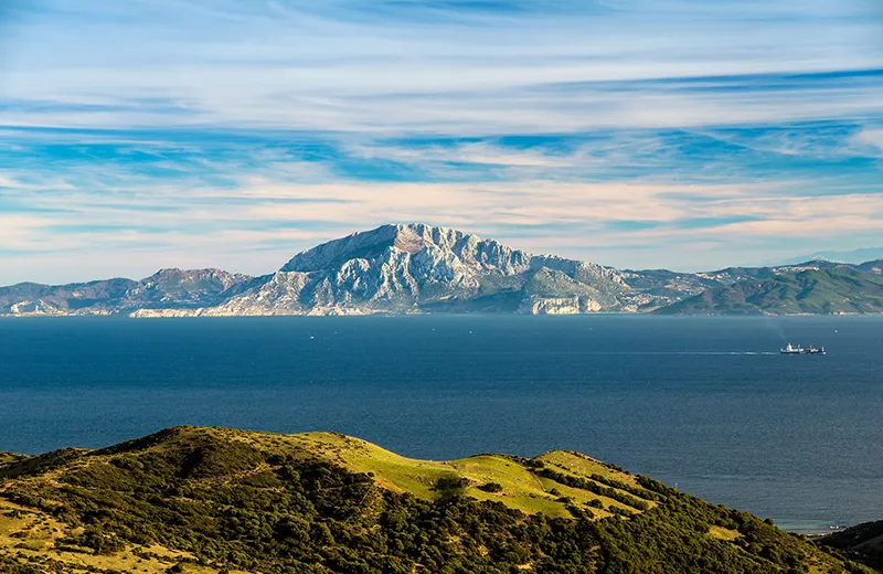
The Strait of Gibraltar is a narrow strait located between Africa and Europe, connecting the Mediterranean Sea to the Atlantic Ocean. The strait is about 14 km wide and up to 300 meters deep. Its length is about 60 km.
The Strait of Gibraltar plays an important geopolitical role, as it is the only major passage between the Mediterranean Sea and the Atlantic Ocean. The Strait is also a key location for controlling sea lanes and trade routes between Europe and Africa.
The Strait of Gibraltar is also known for its rich biodiversity and ecosystems, as it connects different watercourses from different regions. The strait is home to many different species of marine animals, including whales, dolphins, sharks, and many others.
Geography
The Strait of Gibraltar has been known since the earliest mariners, but back then it was considered the truest geographic end of the earth and a symbolic boundary between the human world and the uncharted world. Some believed that if one stumbled here, one could fall off the earth by falling over its edge.
This strait, which gave rise to many myths, separates Europe and Africa and connects the Mediterranean Sea to the Atlantic Ocean. On the European side, it lies at the southern tip of the Iberian Peninsula, and on the African side, at its northwestern shores. At its narrowest point, the strait reaches only 14 kilometers, so that the shores of the two continents can be seen simultaneously.
The shores of the strait are rocky: Europe rises above the ocean in the form of the monolithic limestone Rock of Gibraltar (426 meters), located in Spain, and Africa is dominated by the Moroccan Mount of Jebel Musa. These hills were perceived in ancient times as the “last points of the continent,” and sailors associated the strait itself with the passage between the rocks. Thus the notion of Gibraltar’s “pillars” was culturally ingrained, passed down from people to people. The Phoenicians called this place the “Pillars of Melkart” after the name of their god – the patron saint of seafaring. The Greeks called it the “Pillars of Hercules” and believed that in this way their hero marked the edges of the Ecumene (the part of the world explored by mankind). The Romans nicknamed the rocks “the Pillars of Hercules. Legend has it that at the edges of the strait the tops of the cliffs were crowned with two colossal statues that stood on pillars-steles – hence the word “pillars”. The statues signified the passage into the world of the unknown.
History
The modern name comes from around the 8th century and is associated with the name of the leader of the Arab armies who invaded here in 711, Tariq ibn Ziyad (670-720). The Arabs are credited with the destruction of the legendary statues. They built a fortress which they named after their leader, Mount Tariq, which is Arabic for Jebel At-Tariq. Over time, the name was simplified to “Gibraltar,” from which it became our familiar “Gibraltar. It is now the name of the strait, the mountain, and the city.
The Arabs held sway over the strait until 1309, when the Spaniards briefly succeeded in liberating the land. After the Spanish defeat in 1333 the fortress fell into the hands of the Moors again. Until 1462 the Spaniards were unable to change the situation and the Europeans were enslaved: Arab and Berber (African) pirates founded the port of Tarifa and demanded tribute from all who passed through the strait. According to one version, the word “tariff” came from the name of this town.
In 1469 the marriage of Isabella I of Castile (1451-1504) and Ferdinand II of Aragon (1452-1516) resulted in the subsequent unification of the Spanish provinces into a single state. The Arabs were gradually forced out of the Pyrenees and the remaining Muslim population was forcibly Christianized. Queen Isabella then gave the city of Gibraltar, which grew up around the fortress, a coat of arms with a symbolic image of a golden key, bequeathing to her descendants to hold Gibraltar at all costs. Charles V (1500-1558) carried out the will of Isabella and actually turned Gibraltar fortress into an unassailable bastion, which allowed the Spaniards to hold it until the early 18th century. It is believed that since that time many languages have kept the saying “impregnable as a rock” in which “rock” refers to this very fortress.
Given the importance of Gibraltar to the Spaniards, there is another version of the origin of its name. The word is divided into two parts: “Hiber,” i.e., Iberia (future Spain) and “altar,” meaning “altar,” “altar.” This variant gives a different meaning to the name: “Iberian (i.e. Spanish) altar”.
But in 1704 the fortress was taken by the English during the War of the Spanish Succession (1701-1714). At the signing of the Treaty of Utrecht in 1713 Gibraltar fortress went to Britain. Fourteen times Spain tried to regain the fortress, but it failed. The most notorious British victory was the battle of 1805 at Cape Trafalgar, at the entrance to the Strait of Gibraltar. Admiral Horatio Nelson (1758-1805), who was fatally wounded in the battle, led British forces to victory over the combined French-Spanish fleet of Napoleon I (1769-1821).
The importance of this victory to the British can be seen in many facts: the legendary admiral is buried in Westminster Abbey as a true hero of the nation, and London’s central square is named “Trafalgar Square.
Because of this age-old territorial dispute, relations between England and Spain have repeatedly deteriorated or even been interrupted. In 1985 an agreement on equal rights of Gibraltarians in Spain and Spaniards in Gibraltar entered into force, and at the same time the border between these states was opened.
The British have an omen: as long as the Rock of Gibraltar is inhabited by rare Magot monkeys, the rule of England here will not come to an end. After British Prime Minister Winston Churchill (1874-1965) remarked on the dangerous decline in the monkey population, the position of “officer in charge of the monkeys” was established.
It was from the Gibraltar air base that the Anglo-American operation to land on the coast of North Africa, called “Torch,” i.e., began on November 8, 1942. “Torch.” It is true that the Hitlerites were able to contain this onslaught.
Today the British position their base as a pan-European base, which is simply maintained by England. It is the western link in the chain of Mediterranean naval bases of NATO.
The capital of the Rock State – the city of Gibraltar, which looks like a typical Mediterranean port, living in a mix of cultures: in the architecture of the buildings in the Georgian and Victorian styles interrupt the buildings with features of Spanish-Portuguese, Genoese and Moorish influences, and their language the locals ironically call “spanglish. Gibraltar is an offshore zone. The British presence is reminiscent of the street names and various establishments, the abundance of pubs, police officers in English uniforms and currency – the pound Gibraltar.
On the opposite side of British Gibraltar – the territory of Morocco. The most significant settlement in this part of the country is undoubtedly Tangier. The city has no less remarkable history than its neighbors on the other side of the strait. For half a century, it constituted the international zone of Tangier. A territory with a special status, which in 1912-1956 was governed by several European states (France, Spain and Britain). But during World War II, the balance of power changed. The German-occupied France could no longer control its part of Tangier, and it was occupied by Spain. And at the end of the war, the Arab population of the “zone” began to gain weight and showed discontent with the presence of Europeans.
As a result, in 1956 the Moroccans annexed Tangier. It is now a major port city that retains its autonomy and strategic importance. It remains the most Europeanized city in the country with the permanent French, Spaniards, Germans, Italians, British and other Europeans (including a small Russian-speaking enclave). Not only mosques, but also Catholic, Protestant (Anglican and Lutheran) churches, synagogues and other places of worship are visible on the city skyline.
During its history the Strait of Gibraltar has been closed and opened at least 11 times. This happened, for example, 6 million years ago – the closing of the strait led to an increase in salinity in the Mediterranean Sea and the formation of a 2 km thick layer of evaporites (product of the evaporation of salty water). About 5.3 million years ago, the strait reopened, allowing the Mediterranean Sea to “come alive”. The movement of the lithospheric plates will cause the strait to close again in a few million years.
General information
- Countries: Spain, Morocco and Gibraltar (British Overseas Territory).
- Extremes: Cape Trafalgar and Cape Carnero (Europe), Cape Spartel and Mount Jebel Musa (Africa).
- Languages: Gibraltar – English (and Janito or Llanito/Janito – Andalusian dialect of Spanish combined with English and elements of Italian, Maltese, Arabic and Hebrew); Spain – Spanish; Morocco – Moroccan dialect of Arabic and Berber.
- Ethnic make-up: Gibraltar: English 27%, Spaniards 24%, Genoese and other Italians about 20%, Portuguese 10%, Maltese 8%, Jews 3%, others (Moroccans, French, Austrians, Chinese, Japanese, Poles, Danes and illegal immigrants – Indians, Pakistanis) 8%. More than 83% of the population consider themselves Gibraltarians; Spain: predominantly Spanish; Morocco: Moroccans (Arabs and Berbers) and Europeans (French, Spanish, Portuguese).
- Religions: Gibraltar: Catholicism – 70%, Islam – 8%, Anglicanism – 8%, others (incl. Judaism, atheism) – 11%, Spain: mainly Catholicism, Morocco: Islam (Sunni).
- Monetary units: the Gibraltar pound (Gibraltar), the euro (Spain), the Moroccan dirham (Morocco).
- The most important ports are Gibraltar (Great Britain), La Linea, Ceuta, Algeciras (Spain), Tangier (Morocco).
- Airports: Gibraltar International Airport (Gibraltar), Ibn Batuta International Airport (Tangier).
- Length: 65 km.
- Width: 14-44 km.
- Fairway depth: up to 338 m.
- Maximum depth: 1181 m.
- Average amount of incoming Atlantic water: 55,198 km3 per year.
- Average temperature of the Atlantic water: +17°C.
- Average salinity of Atlantic water: more than 36%.
- Average amount of outgoing Mediterranean water: 51,886 km3 per year.
- Average temperature of Mediterranean water: +13.5°C.
- Average salinity of Mediterranean water: about 3%.
- From Europe to Africa, a ferry crosses the Strait of Gibraltar (35 min.).
Economy
- Industries: naval shipyard, shipbuilding and ship repair.
- Electricity industry.
- Services: tourism, transport (shipping), trade.
Climate and weather
- Average temperature in January: +13°C.
- Average temperature of July: +24°C.
- Average annual rainfall: 767 mm.
Attractions
- Natural Park of the Bay of Gibraltar (Tarifa, Spain); man-made tunnels of different times in the Rock of Gibraltar and an observation deck on it; St. Michael’s Cave (Gibraltar).
- City of Gibraltar: Moorish castle (from XI century), the church of Our Lady of Europe (mid XV century). Catholic Cathedral of St. Mary the Crowned, the Anglican Cathedral of the Holy Trinity (1825). St. Andrew’s Church (1854), the Great Synagogue (1724); Museum of Gibraltar.
- Tangier City: Old City, Dar el-Mahzen Palace (XVII century), the building of the American Mission, Grand Socco and Petit Socco (large and small squares), Grand Mosque of Tangier, Kasba Mosque, St. Andrew’s Anglican Cathedral, Continental Hotel.
- Landscape: Grottoes of Hercules (in the caves at Cape Spartel), beaches from Cape Spartel (length 47), Remilla Park, Terrace Slukya.
Fun facts
- According to one version, Hercules Pillars became the prototype of the two vertical lines in the symbolic image of the dollar, and the mythological serpent Python wrapped around them could become a winding “S”-shaped line.
- During World War II, all German submarines that entered the Mediterranean Sea through this strait were blown up there. Except for one, the U-26.
- Back in the days of the Phoenicians’ voyages, the Rock of Gibraltar was like a vast altar in the open air: sacrifices were made here before entering the waters of the Atlantic.
- One ambitious project of the twentieth century power engineers proposed to lower the Mediterranean sea level by 200 meters artificially in order to install dams with several power plants in the strait.
- In the Strait of Gibraltar, the currents are in different directions: the surface current to the east and the deep current to the west.
- In Gibraltar on the square of the Casemates there is still a ceremony of handing over the keys, because in the past the gates of the fortress were actually locked with a key.
- The last world record in women’s swimming belongs to 49-year-old Penny Palfie who in 2010 crossed the Strait of Gibraltar in 3 hours and 3 minutes.
- The Strait of Gibraltar is open to civilian and military vessels of all countries. It is also open to all civilian aircraft.
- From time to time there is the idea of creating either a tunnel under the strait or a bridge over it – and then such a bridge would be the longest (15 km) and the highest (over 900 m) in the world.
- The Rocks of the Strait of Gibraltar are called the Pillars of Hercules because in different versions of the myth of the feat, associated with his journey after the miraculous cows of the giant Herion, Hercules is attributed either the creation of these pillars, or their discovery on the edge of the western world.
- The waters of the Mediterranean Sea and the Atlantic Ocean do not mix. They retain their differing properties. And this was known in ancient times, and modern scientists simply managed to explain this fact by the presence of the surface tension of water.
- According to legend, the bottle mail was invented in the III century BC by the Greek philosopher Theophrastus, who threw several sealed vessels with messages in the Strait of Gibraltar. In this way the naturalist ascertained that the water of the Mediterranean Sea was drawn from the Atlantic: months later one of the jars was discovered in Sicily.
- Another name of the strait, the Arabic Bab el-Zakat, means “Gate of Mercy”.


