Despite the fact that the Greek geographer and historian Strabo in 18 AD called the river in the center of Europe by the Old Scandinavian word “Elfr” (river), modern scientists doubt that the name Elbe has Scandinavian roots. If only because it does not flow into the Baltic Sea and has no outlet to Scandinavia. Today it is generally accepted that the origin of the name Elbe comes from the Indo-European word “albo” (white, or light), the later Latin “albis” (light) and the Gaulish “albis” (white water) or the Celtic Elb (river).
Geography and ecology
The Elbe belongs to the plain type of river, characteristic of the lowland part of Central Europe, with snow and rain feeding, with maximum water levels in spring and minimum (low water) in summer.
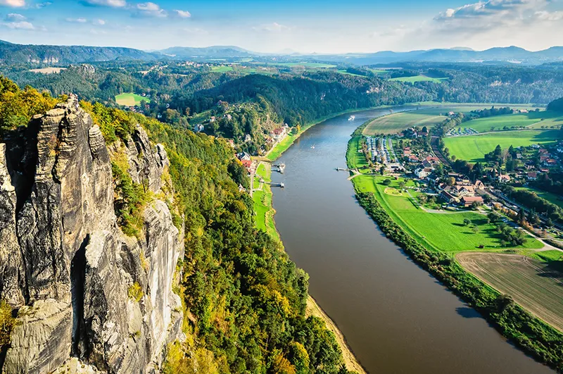
The plain type of the river is also expressed in the characteristic form of its valley, well developed by slow flow, with frequent multi-kilometer smooth bends (meanders). The Elbe River is like a natural chisel, which easily deepened the channel and drew new bends over thousands of years. Only at the end of its difficult journey through rocks, mountains (the Ore Mountains in Saxon Switzerland) and Cretaceous sediments does it arrive in its lower reaches at the Gesta, a hilly lowland formed by soft and pliable sand and sedimentary rocks formed during the last ice age.
Due to the flat nature of the terrain, there are virtually no large hydroelectric power plants on the Elbe, and those that do exist are located in the upper reaches (Czech Republic), where the current is relatively fast and there is no wide floodplain, which would inevitably become the bottom of a reservoir if a hydroelectric power plant were to be built. Taking into account the demands of the German public, the country’s authorities have abandoned nuclear power, but they also consider it impossible to develop a system of hydroelectric power plants on the Elbe, because in such a case the few remaining ecosystems – the grass cover of floodplains and deciduous forests represented by disappearing elms, oaks and willows – will be disturbed. Ecologists cite the example of some tributaries of the Elbe, whose regime is completely regulated and the natural existence of vegetation and soil cover is disturbed, as the tributaries have actually turned into canals.
A complex system of canals connects the Elbe with the Baltic Sea and the rivers Rhine, Weser, Odra, Rhone and Marne. Many canals have existed since the Middle Ages, such as the Elbe-Lübeck Canal in Germany, which connects the Elbe with the River Trave and provides access to the Baltic Sea. The canal was built in 1390-1398 and is one of the oldest in Europe, with wooden locks, some of which have survived to the present day.
Shipping on the Elbe is one of the busiest in the world. Hamburg is one of the largest seaports in the world (cargo turnover of about 120 million tons per year), although it is 110 km from the sea. The estuary is so wide that sea tides can be observed in Hamburg and whales swim here, although very rarely.
The most important problem of the Elbe today is considered to be ecology. The International Commission for the Protection of the Elbe monitors the state of the environment in the river basin, including both Czech and German parts of the river, taking tough decisions, even political ones.
Through the efforts of ecologists, many species of fish have been preserved in the Elbe, but the composition of the river water is already far from natural, which is characteristic of all major European rivers. A large program to restore the river is underway in the Czech Republic and Germany, and one of its achievements is that in many sections it is already suitable for bathing.
History
The river was known as the Albis to the ancient Romans and they longed to cross it, pushing the borders of the Roman Empire further east, away from the Rhine. However, the legions of the Lower Germanic procurator Publius Quintilius Varus were ambushed in the Teutoburg Forest (Lower Saxony) in 9 AD and were annihilated by the Germans under the command of Arminius and Sigimer. Up to 25 thousand soldiers died, Var himself committed suicide, and Emperor Augustus let go of his beard as a sign of mourning and incessantly repeated the phrase that later became famous: “Quintilius Var, give me back my legions”.
In the Middle Ages, the Elbe separated the western part of Germany from the so-called East Elbe (Prussia). In the Middle Ages, the Elbe separated the western part of Germany from the so-called East Elbe (Prussia), where the feudal dependence of the peasantry was very strong and where only rich feudal lords lived. Over time, the owners of vast territories were called East Prussian Junkers. The lands north of the lower Elbe were called Northern Albinia in those times. At the beginning of the IX century the Elbe was the eastern border of the Frankish state of Emperor Charlemagne, and later river navigation on the Elbe became the key to the prosperity of the Hanseatic League. In the XIII-XVII centuries. this union of free German cities in Northern Europe was in dire need of protection of trade and the merchants themselves from robbery taxes, which they imposed feudal lords, and in protection from pirates. The Elbe became the most important trade route for German merchants.
The Versailles Peace Treaty of 1919, which officially ended the First World War of 1914-18, singled out the question of navigation on the Elbe as separate articles (Nos. 363, 364). Henceforth all disputes were to be settled by the International Elbe Commission, headquartered in Dresden.
In 1945, before the end of the Second World War of 1939-45, German troops found themselves squeezed between Allied armies from the west and the east. On April 25, the forward units of the victorious armies reached the town of Torgau on the Elbe. An American patrol of U.S. Army Lieutenant William Robertson met with Lieutenant Alexander Silvashko’s soldiers on a destroyed bridge over the Elbe. A photograph of the lieutenants shaking hands was also taken at that time. The historic event was called “Meeting on the Elbe”.
After World War II, when two German states, the FRG and the GDR, took the place of a united Germany, West Germany was faced with an unpleasant fact. Henceforth, internal navigation on the Elbe ran through the territory of East Germany. To bypass the border section of the river, West Germany built the Elbe-Seiten Canal, or Elbe Side Canal, between the West German section of the Mittelland Canal and the lower reaches of the Elbe.
But it wasn’t just politics and war that left their mark on the river’s banks. The river itself could also show its character. In August 2002, a flood occurred in the upper reaches of the Elbe: in Dresden, the water level rose 9.4 meters higher than usual. Tens of thousands of people were evacuated, about 30 thousand houses were flooded, 540 km of railroad tracks and 180 bridges were completely destroyed.
General Information
- Location: Central Europe. It flows through the Czech Republic (358.3 km) and Germany (795.7 km).
- Feeding method: snow melt water.
- Source: the Giant Mountains.
- Mouth: near the town of Cuxhaven, in the North Sea.
- Major tributaries in the Czech Republic: Jizera, Ohře, Vltava, Orlice.
- Major tributaries in Germany: Schwarze-Elster, Salle, Hafel, Elde, Mülde.
- The largest ports: Hamburg, Magdeburg.
- Largest cities: Hamburg, Magdeburg, Dresden, Lüneburg, Wittenberg, Dessau, Riese, Meissen, Decin, Usti nad Labem, Pardubice, Hradec Králové.
- Length: 1,154 km.
- Length of navigable section: 940 km.
- Basin area: 148,268 km2.
- Average water discharge: 308 m3/s at the Czech-German border, 711 m3/s in the lower reaches.
- Width: 100-150 m at Dresden, 300-500 m at Hamburg.
- Depth at high tide: 16.3 m.
- Elevation difference from source to mouth: 1386 m.
- Population of the basin: 24.5 million.
Economy
- Industry: electric power generation (hydroelectric power plants in the upper reaches).
- Fishing.
- Services: tourism, transportation (river navigation).
Climate and weather
- Humid temperate.
- Average temperature in January: about 0ºС.
- Average temperature in July: +16.5ºС.
- Average annual precipitation: 400-1700 mm.
Attractions
- Czech Folk Park Krkonoše (source of the Elbe River)
- Hradec Králové: Town Hall (1614), Cathedral of the Holy Spirit (XIV-XV cc), White Tower (1717).
- Nymburk: Bridge over the Elbe
- Gothic fortress in the valley of the Laba and Orgže rivers (Litoměřice, Czech Republic)
- Dresden Elbe Valley: A section of the Elbe River Valley in the Saxon capital of Dresden, listed and then removed from the UNESCO World Heritage List
- Meissen
- Magdeburg
- Hamburg: St. Michael’s Church (1751-1762), Bridge of Consolation (1266), City Hall (1897), Old Elbe Tunnel, Lake Aussenalster, Hamburg Port, Natural Sea Harbor at the mouth of the Elbe.
Fun facts
- On the island Neuwerk, located at the mouth of the Elbe, in Hamburg, there is a lighthouse, built in 1299. The lighthouse is considered the oldest civilian structure of Hamburg, which has survived to this day.
- In the 1970s, representatives of the USSR claimed that the ashes of German leader Adolf Hitler had been removed from a secret burial site and dumped into the waters of the Elbe.
- To combat river ice in the second half of the XIX century. in Hamburg built a unique type of ships – river icebreakers. All of them were steam-powered, the length of the largest reached 30 meters, the total number of the flotilla was about ten units, and they could go 120 km upstream. The flotilla was so successful that it changed the ice regime at the mouth of the Elbe.
- The brightly colored ferries on the Elbe are not only one of the common modes of transportation, but also a tourist attraction. Each ferry is painted in the colors of the company-owner Most of the ferries are of an extremely rare type, using the power of the river current: a rope is fixed with one end in the middle of the river, the other end on the ferry, and by steering the ferry at a certain angle to the river current, the ferryman guides the vessel to the other side. The Dresden Transportation Company has five yellow and white ferries; the oldest was launched in 1929.
- At high tide, the Elbe is 16.3 meters deep at its mouth. The largest ship that ever went up to Hamburg was the Paradise N, a cargo ship 332 m long, 58 m wide and with a displacement of 322,398 tons.
- Hamburg has the world’s largest harbor warehouse district, built in the late 19th century on wooden piles driven into the shoal on the Elbe. The streets here serve as river canals.


