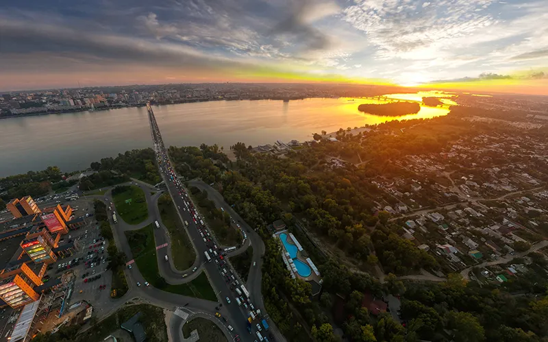
The Dnieper River is one of the largest and most important rivers in Europe. It flows through Russia, Belarus, and Ukraine and is about 2,290 kilometers long, making it the third-longest river in Europe after the Volga and Danube.
History
Even in ancient times, long before it became part of the famous route “from the Varangians to the Greeks,” the Dnieper served as a means of communication between the Baltic lands and the Black Sea.
The ancient Greeks knew about this river already in the 5th century B.C. Herodotus called it Borisphenes, “the river from the north. Later, Roman historians gave it the name Danapris. There is a suggestion that this word comes from the Scythian language in which dan means “river” and apr means “deep”.
The route “from the Varangians to the Greeks” contributed to the expansion of the Vikings, who sought to colonize the lands adjacent to it. That is why the Dnieper can be called the cradle of Russia. According to one of the hypotheses, the ancient Russian statehood arose as a result of the call of the Varangians to the Rus tribe for reigning.
With the formation of the state and the development of the trade route “from the Varangians to the Greeks,” the importance of the Dnieper River increased despite the rapids in its lower reaches, which hampered navigation. Along the middle course of the river in the IX-X centuries the following cities grew: Kyiv, Smolensk, Lubech, Pereyaslav, Vyshgorod and Chernigov (50 km from the Dnieper, on its left tributary the Desna). During this period, the Slavs called the Dnieper Slavutich.
As a result of the Mongol-Tatar invasion, the outflow of the Dnieper population to the north and the splitting of Russia into separate principalities, the route “from the Varangians to the Greeks” ceased to exist, and the commercial importance of the river declined.
In the XIV-XVI centuries, most of the Dnieper River belonged to the Grand Duchy of Lithuania, and from 1569 – to Rzeczpospolita. In the 16th century the Cossack community – Zaporizhian Sich – appeared in a bend of the Dnieper below the rapids. This military organization of the free Ukrainian Cossacks, on the one hand, resisted the Turks and Crimean Tatars, on the other – the pressure of the Polish-Lithuanian government. It was here, in 1643, that the uprising against the Rzeczpospolita started, which turned into the war of liberation led by Bohdan Khmelnitsky and the unification of the Left-bank Ukraine with Russia. The territory of Ukraine, located on the right bank of the Dnieper, remained under the rule of the Commonwealth of Poland until its partition in 1793.
During the reign of Catherine II, in the Dnieper region emerged and strengthened the first industrial centers – Katerinoslav (now Dnep), Nikopol, Aleksandrovsk (now Zaporozhye), Kremenchug. The emergence of the steamship line played an important role in the development of trade in timber (primarily in the upper reaches) and agricultural products coming from the southern regions. The only problem was that the steamships could not pass the Dnieper rapids. Travelers had to go ashore in Yekaterinoslav and transfer to postal carriages to get to Aleksandrovsk, where navigation was resumed.
Only in 1932 – after the commissioning of the first unit of the Dnieper power plant – the problem was eliminated. The rapids were flooded as a result of the construction of the dam and the formation of the Dnieper Reservoir. A new era in the development of the Dnieper began.
Once, to avoid the dangerous rapids in the lower Dnieper, people dragged the ships along the bank by drag. Construction of powerful hydroelectric power in the XX century helped to tame the waters of the Dnieper.
Ukraine’s largest river
Like the Volga and Don rivers, the controversial character of the Dnieper was formed during the glacial period. Glacial arms penetrated deep into the valley, reaching the latitude of Dnepropetrovsk. They determined the topography of the channel and banks of the Dnieper. Starting from a brook on the slope of the Valdai highlands, the river gains strength and becomes navigable near Smolensk, about 300 km from its source. After passing through the local forests, the river crosses the moraine Orsha uplands and flows through the territory of Belarus almost strictly from north to south. Expanding more and more to the south, the Dnieper forms a branched hydrosystem. Between Mogilev and Kyiv the Dnieper valley widens, the floodplain reaches a width of 14 km. In this interval several rivers flow into the Dnieper: the Berezina and Pripyat from the west, and the Sozh and Desna (the longest tributary of the Dnieper) from the east. Having absorbed large quantities of water from its tributaries, the Dnieper accelerates through Ukraine, gradually giving up its resources to the forest-steppe and steppe regions. Here the river valley often changes its topography, its width sometimes reaches 18 km. The right bank is much higher than the left, steep and precipitous.
In its middle reaches Dnieper is a chain of reservoirs (from Kyiv to Kakhovka), and only in the lower reaches is there a part of the natural channel.
The Dnieper Reservoir (in Zaporozhye) was the first to appear on the seemingly indomitable river.
In 1939, the Dnieper hydropower plant reached its design capacity. Partially blown up during the war, it was restored by 1950. Dneproges was followed by the construction of Kakhovskaya, Kremenchugskaya, Kievskaya and Dneprodzerzhinskaya. Dnieper cascade of dams was completed by Kanevskaya HPP, finally put into operation in 1975. The huge potential of these hydroelectric power plants still determines the industrial development of independent Ukraine, for which the Dnieper is the main source of energy. And a large number of canals provides water supply and irrigation of the southern and eastern regions of Ukraine.
However, due to such intensive use of the Dnieper, a number of major environmental problems arose. Industrial and domestic water pollution has become catastrophic in recent years. Radioactive shadow over the waters of the Dnieper still hangs the accident at the Chernobyl Nuclear Power Plant, located 30 km from the Kyiv reservoir. The reservoirs themselves are practically a chain of reservoirs with standing water in the place of ruined unique ecosystems and landscapes. Finally, such a large number of hydraulic structures in the absence of regular upgrading and sufficient funding is gradually falling into disrepair, which threatens a man-made disaster.
General Information
- The largest tributaries of the Berezina, Pripyat, Sozh, Desna, Sula, Psyol, Sluch, Vorlsca and Ingulets.
- Countries through the Dnieper flows: Russia, Belarus and Ukraine.
- The largest cities: Smolensk, Orsha, Mogilyov, Kyiv, Cherkasy, Kremenchug, Kamenskoye, Dnieper, Zaporozhye, Nikopol and Kherson.
- Artificial reservoirs: Kakhovskoe, Dneprodzerzhinskoe, Kremenchug, Kievskoe.
- Hydroelectric power stations: Dnieper hydropower station (Zaporizhzhya), Kremenchug, Kyiv, Kanev, Dneprodzerzhinsk, Kakhovka hydropower stations.
- Length: 2201 km.
- Basin area: 504,000 km2 .
- Height of the source: 220 m (Valdayskaya upland).
- The slope of the river: 0.1 m/km.
Economy
- Mineral resources: brown coal, iron, manganese, oil, natural gas.
- Industry: petrochemical, metallurgy, electrical engineering, power engineering.
- Agriculture: cultivation of sugar beet, cereals, potatoes, hemp, flax, hops, tobacco; animal industries.
Climate and weather
- Temperate, in some places with continental influences (large seasonal differences).
- Freezes in late November-early December, opens in late March-early April.
- Maximum ice thickness: 60-80 cm.
- Ice drift lasts 4-9 days.
- Average summer temperature: 19-22ºC.
Attractions
- Kiev
- Cherkassy
- Dnieper
- Kremenchug
- Nikopol
- Chernihiv
- Dnieper hydropower
- Bridges and reservoirs
Fun Facts
- The first fortress over the rapids of the Dnieper, the prototype of the Zaporozhye Sich, was Khortytsky castle, built by Volyn Prince Dmitry Vishnevetsky in 1553.
- The Commission on the construction of the Dnieper Hydropower Plant in the 1920s was headed by Leon Trotsky and it was he who led the construction in its initial stages.
- Dnieper Hydropower Plant is connected with a tragic page in the history of World War II. In August 1941, the dam was blown up by retreating Soviet troops, which caused a huge wave that killed tens of thousands of people, not to mention the livestock, river boats, food supplies and industrial equipment.
- In 1943 the Battle of the Dnieper took place, one of the most important in the Great Patriotic War. As a result, the plan to turn the river into a defensive frontier was foiled.
- In March 2010, a major environmental disaster occurred on the Dnieper River near Kiev. Due to the rapid release of water from the Kiev reservoir, tons of fish were crushed by the lowered ice. It is estimated that 50-60% of the fish died.
- On the night of June 6, 2023, the spillway dam of the hydropower plant was destroyed, locals reported on social media that they heard a strong explosion around the time the dam was breached, at 2:50 am, an explosion with magnitude 1-2 at 2:54 am in the area of the hydropower plant at the same time was detected by the NORSAR seismic sensor network. Since late February 2022, the plant has been taken over by units of the Russian Armed Forces attacking the Kherson region from Russia’s 2014 annexation of the Crimean Peninsula.


