The Bosphorus is the strait that connects the Sea of Marmara and the Black Sea, separating Europe from Asia. It extends for 30 kilometers and is 700 meters to 3.7 kilometers wide. The Bosporus is one of the most important straits in the world, as it serves as a key route for transporting oil and other goods between Europe and Asia. In addition, it is also of great historical and cultural importance, as on its shores is located the city of Istanbul, which is one of the most important cities in the history of the East and the West.
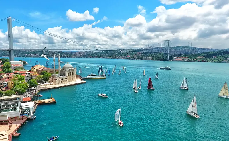
On the shores of the Bosphorus Strait, antiquity meets modernity. The Ortaköy Mosque, or Great Mosque of the Bosphorus, built in the Ottoman Baroque style in 1853-54, looks especially good against the backdrop of the Ltaturk (Bogaziki) Bridge, the first suspension bridge spanning the Strait.
History
According to an iconic ancient legend, the all-powerful god Zeus fell in love with Io, daughter of the Argive king and river god, which didn’t please Zeus’ consort Hera. Io turned into a white cow and, trying to save herself, went down into the waters of the strait, which has since been called the “cow ford,” or Bosporus.
In fact, it is not known exactly why the ancient Greeks called the strait that way: “Bos” – bull, “Poros” – ford, that is – “bull ford”. But “cow” was fixed.
The science of historical geology also has no unambiguous version of the origin of the Bosporus. The most common – “Black Sea Flood Theory” – is that the Bosporus was formed about 7500-5000 years ago. According to this theory, earlier the level of the Black Sea and the Mediterranean Sea was below the level of the World Ocean by 120 m, and the seas were not connected in any way. At the end of the last ice age, as a result of the melting of huge masses of ice and snow, the water level in both bodies of water rose sharply, by 140 meters, and a powerful water current broke its way from one sea to the other. This is indicated, in particular, by the bottom topography, as well as by the change of aquatic plants and sediments from freshwater to saltwater around the time mentioned above. Another reason for the appearance of the strait could have been an earthquake.
The Bosphorus Strait has a crucial geopolitical position. Since the Trojan War in the 13th and 12th centuries BC, it has repeatedly caused international tensions, especially during periods of weakening of one of the major great powers.
During the Byzantine Empire (IV-XV centuries), and after its fall, during the Ottoman Empire, the Bosporus Strait remained an internal affair of those states.
The Ottoman period in the history of the Strait left a significant trace in the architecture of buildings on the shores of the Bosporus. After the conquest of Istanbul, the Padishahs built many fortifications here, and not only that. At first they built in the center of the city but with the advent of steamboats in the 19th century, luxury summer residences began to be built on the Bosporus coast, farther from the sea.
At the end of the 17th century, the Russian Empire established itself on the coasts of the Sea of Azov and the Black Sea, and the problem of the Bosphorus and the Dardanelles, which became known in history as the “Straits Question”, emerged at the same time.
First, the Bosphorus Strait is very narrow, so it is easy to “lock up.” Second, the shores of the Bosphorus belong to one state, Turkey. Third, the strait connects the open Mediterranean Sea to the closed Black Sea. At all times, Turkey used its exclusive position on the Bosporus and allowed foreign ships through the strait, issuing them “Firmans,” a kind of license for the right to trade with Black Sea countries. The Bosporus has always been a subject of disputes between Russia and Turkey, causing several Russian-Turkish wars. Russia was able to make Turkey to sign the Treaty of Cucuk Kainarji in 1774, under which Russian ships could freely sail in the strait.
After the end of World War I, the 1920 Treaty of Sèvres declared the Bosporus a demilitarized zone under the control of the League of Nations. Today, the Turkish Straits Regime Treaty signed in 1936, under which the Bosporus is an international navigable zone, is in force. Today, in terms of modern international law, the Bosporus is an “open sea”: merchant ships of all countries have freedom of passage through the strait both in peacetime and in wartime. But Turkey has reserved the right to limit the movement of vessels of non-Black Sea countries, in particular its longtime enemy, Greece, and has introduced a regime of prior notification of the passage of warships.
The Strait between the Black Sea and the Sea of Marmara
Much of the traffic through the Strait is oil from Russia and the Caspian region, delivered to Western Europe and the U.S. by tankers loaded at terminals in the Russian port of Novorossiysk.
Navigating the Bosphorus Strait presents significant challenges. The fairway used by the ships is very tortuous, has an S-shaped configuration, and follows an equally tortuous coastline. Thanks to the exceptionally well-coordinated work of the coastal services in the lighthouses and control rooms, the modern history of the strait does not know major disasters. Since 1960, there have been only two dozen incidents here without significant loss of life or environmental damage.
The flora and fauna of the Bosphorus are no different from those of the Mediterranean, and the main commercial fish species here is mackerel.
The idea of a bridge over the Bosporus was born in ancient times. But only in the second half of the XX century, after long and heated discussions two bridges were built to connect the two banks of the strait.
The Bosphorus Bridge – the first suspension bridge across the Strait – with a total length of 1,510 m was opened for traffic in 1973. It bears the name of Ataturk, but locals more commonly refer to it as Boğazıki (Turkish for “strait”). It connects the European and Asian parts of Istanbul. The height above the water is 64 meters. Every day more than half a million people cross the bridge. For the first four years people could walk on it, but later it was prohibited, because the bridge was regularly used by those who decided to commit suicide. Pedestrians are advised to use the ferries that have been running between the banks of the Bosphorus since the time of the Persian King Darius I (V-IV centuries BC).
The bridge of Sultan Mehmed Fatih has the same overall length as its older brother and was completed in 1988. The bridges are 5 km apart.
For ease of movement on the strait there are several towers to control sea traffic, or simply lighthouses. All of them are not similar to each other. The first lighthouse tower was installed by the Byzantine Emperor Alexei I Komnin in 1110 The Maiden Tower, or Leandra Tower, is one of the symbols of Istanbul, which has been restored many times.
On the European coast of the Bosphorus is one of the oldest and most prestigious districts of Istanbul, Beşiktaş. It is also home to one of Istanbul’s ports, from which ferries depart for the Asian side of the Bosphorus. Istanbul’s most impressive square, Barbarossa Square, is also in the Besiktas district and houses the Nawal Museum and the mausoleum of Holy Roman Emperor Frederick Barbarossa, who was killed, according to one version, while crossing the Bosporus during the Third Crusade in 1190.
If it’s a sunny day, locals swim in the Bosphorus from Kennedy Embankment, in the Sultanahmet neighborhood, even despite coastal fortifications in the form of randomly scattered boulders, constantly passing ships and, to say the least, not entirely clean water. This recklessness can probably be explained by the fact that in recent years the city’s population has changed markedly in both number and composition, with more people coming from far-flung rural provinces.
And native Istanbulis no longer come here.
The greatest number of attractions on the Bosphorus is concentrated in the area of Sultanahmet. These are the most famous historical monuments of Istanbul: the Hagia Sophia (Hagia Sophia Cathedral), the Blue Mosque (Ahmediye Mosque, in honor of Sultan Ahmed), the Hippodrome, Topkapi Palace, Basilica Cistern, the Archaeological Museum of Istanbul, and the Sulaymaniye Mosque. In 1985, the area was inscribed on the list of UNESCO World Heritage Sites.
General Information
- The strait between Europe and Asia.
- It connects the Black Sea with the Sea of Marmara and, together with the Dardanelles, with the Aegean Sea, thus with the entire Mediterranean basin.
- Administrative affiliation: Turkey, Marmara Region, Province of Istanbul.
- Biggest city: Istanbul.
- Language: Turkish.
- Currency: Turkish Lira.
- Religion: Islam
- Length: 31 km.
- Width: 3329 m at the northern entrance, 2826 m at the southern entrance.
- Maximum width: 3420 m.
- Minimum width: 700 m.
- Fairway depths: 36 to 124 m.
- Average depth: 65 m.
- Maximum depth: 110 m.
- Minimum depth: 18 m in the north, 13 m in the south.
- Population: about 17 mln people (2001).
Economy
- Shipping: 48 thousand ships per year.
- Tourism.
Climate and weather
- Moderately continental, peripheral zone subtropical. Influence of cold winds from the north.
- Average annual air temperature: +15°C.
- Average annual temperature of water: +14+18°C.
- Average annual precipitation: 850 mm.
- Relative humidity: 71,5%.
- Water salinity: in the surface stream prevails distributed (18%o) Black Sea water, and in the oncoming deep stream water salinity is 38%o.
- Problems: fog, poor visibility, strong winds.
Attractions
-
European coast
- Golden Horn Cove.
- Buildings: Rumelihisar Fortress (mid XV c.), Topkhane Castle (mid XIX c.), Cifte Saraylar Palace (mid XIX c.), Dolmabahce Palace (mid XIX c.).
- Influential buildings: Kylyc Ali Pasha Jami Mosque (end of 16th century), Dolmabahçe Jami Mosque (mid 19th century), Ortakoy Mosque (mid 19th century).
- Museums: Fine Arts Museum and Maritime Museum.
- Yildiz Park.
- Saryer fish market.
-
Asian side
- Leandre Tower (XII cent.).
- Cult constructions: mosque of Mihriman Sultan Jami (middle of XVI century), mosque of Yeni Valide Jami (beginning of XVIII century).
- Buildings: Anadoluhisari fortress (end of 14th century), Veylerbey palace (middle of 19th century), Kuchkzsu villa (middle of 19th century), Haydar Pasha Tara station (19th-20th centuries).
- Haidar Pasha Liman port (end of XIX c.).
- Chamlydzha hill.
-
Other
- Bridges: Ataturk Bridge (Boğazıki), Sultan Mehmet Fatih Bridge.
- Adapar (Princes’ Islands, Marmara Sea).
Fun Facts
- On the surface of the Bosphorus, the current usually heads from the Black Sea to the Sea of Marmara. At some depth the current changes direction and goes in the opposite direction.
- During the winters of 1621-1669 the strait was covered in ice. This time was characterized by a general drop in temperature in the region and is referred to in climatology as the “Little Ice Age.
- The “Black Sea Flood” may have been the basis of the legend of the Flood, which is present in the folklore of all the peoples inhabiting or having inhabited this region, and may also have been the basis for the story of the “Dardanic Flood” from the tales of Troy.
- Every year in Istanbul, in mid-summer, there is an intercontinental swim across the Bosporus, in which anyone who has time to register can take part.
- On November 27, 2010 Ukrainian marathon swimmer Oleg Sofyanik swam the Bosphorus Strait in six hours. The race was dedicated to the preservation of the natural environment of the Bosphorus. The athlete was helped by a strong southerly wind and a cross current. The water temperature was 14 degrees Celsius.
- On May 15, 2005, American tennis star Venus Williams played a demonstration game against Turkish tennis player Ipek Senoglu on the Bogaziki Bridge. It was the first literally “intercontinental” match.
- The construction of the Marmaray railway tunnel between the banks of the Bosphorus is already underway, to be completed in 2013. In 2010, the Turkish government announced to the public that another road bridge over the Bosphorus is planned, in the northern part of the strait, on the coast of the Black Sea. The eight-lane bridge is 1,275 meters long and will connect the Northern Marmara Expressway with the Trans-European Highway.


