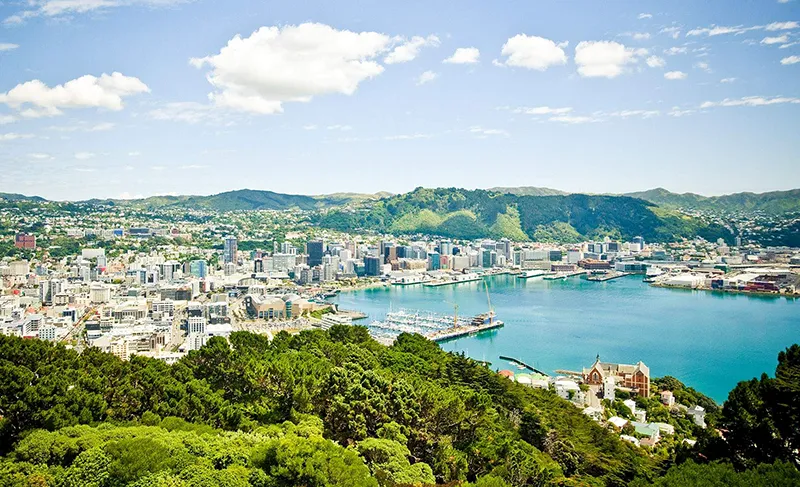
Wellington is the capital of New Zealand and the second largest city in the country after Auckland. It is located on the northern island of New Zealand on the Cook Strait, which separates the island from the South Island. Wellington is the political, economic and cultural center of New Zealand, and home to many government offices, museums, galleries and theaters. The city is also known for its scenic natural attractions, including Mount Victoria and Wellington Bay. Wellington is also considered one of the most scenic cities in the world and is often referred to as the “New Zealand Capital of Culture.”
Geography
The city’s neighborhoods are nestled on the slopes of the mountains surrounding the coast of Wellington’s deep Pacific Bay, formerly called Port Nicholson. Wellington Bay is home to inland Lambton Bay, whose waters directly bathe the city’s shore. Both the bay and the bay are of volcanic origin. They are part of the Cook Strait that separates New Zealand’s North and South Islands.
There are three islands in Wellington Bay that are part of the city. One of them, Matiu-Soms, was used as a quarantine station for migrants and animals and as an internment camp during World Wars I and II. It is now a nature reserve.
The natural eastern boundary of the city is the Rimutaka Hill, which separates the city from the wide plain of Vairarapa, the main wine-producing region of the country. Because there is relatively little land between the sea and the mountains, the population density here is the highest in the country.
Wellington’s climate is very variable, as the city is located in the latitude of the “Roaring Forties,” an oceanic area between 40°-50° S, where strong and persistent westerly winds from the Cook Strait blow, causing frequent storms, for which the city has been nicknamed Windy Wellington, or simply the Windy Gale.
History
The first people from eastern Polynesia, migrating across the South Pacific, settled here between 1250 and 1300. The culture of the Maori people gradually developed, and they welcomed the first white travelers. In 1642, Dutch navigator and merchant Abel Tasman and his crew landed here. The Maoris killed four sailors; the Dutch responded with buckshot. After that Europeans set foot on this land again after fifteen hundred years, and gradually they managed to establish trade with the Maori.
The first European settlement on today’s Wellington arrived in 1839 with the British ship Tory, followed by the Aurora in 1840. The newcomers – only about two hundred in all – built houses at the mouth of the Hutt River and named their settlement Wellington. So they expressed their gratitude to the illustrious English commander, Field Marshal Duke Arthur Wellington. The settlers were grateful to him for supporting in London the ambitious plans of Colonel William Wakefield, who had the idea of founding a new city here.
The city was not lucky at first. In 1840 a massive flood on the Hutt River forced residents to move Wellington further south. In 1848 a major earthquake devastated nearly the entire city. The earthquake of 1854 caused many casualties among the citizens. This is when all New Zealanders began to develop the well-known “Wellington character” of the residents, who stubbornly rebuilt the city over and over again.
In 1865 an event occurred that fundamentally changed the lives of citizens: from a provincial town Wellington became the capital, where it was moved from Auckland on the North Island. The reasons were obvious: the South Island was experiencing a booming economy, its population grew dramatically, so it was expected that the island would create a separate colony within the British Empire, which did not suit the government. At the same time, Wellington had a convenient bay and an extremely geographical position, being located by the strait, in the center of the country.
In 1907, New Zealand became so independent that it achieved dominion status (a self-governing colony of Great Britain). Wellington remained the capital of New Zealand, a status it enjoys to this day.
Population
The city is part of a large agglomeration, occupying the popular tourist beachfront Kapiti, or Gold Coast, part of the Wairarapa Grape Plain, the coast of Porirua Bay, the Hutt River Valley and several other areas.
Wellington’s capital status is underscored by the fact that it is the residence of the Governor-General of New Zealand, a representative of the British royalty. The economic importance of Wellington is also due to the presence of the most important – both for the country and for the whole of Oceania – seaport with a cargo turnover of about 5.6 million tons per year. The country’s leading computer technology and film companies are concentrated here.
The average income of Wellington residents is much higher than the national average and exceeds even the Oakland average. In 2012, it reached $78,952.
The city’s population is made up of Anglo-New Zealander and Maori people, as well as numerous groups of Irish, Dutch, Scottish, Chinese, and Indians. The English language is used in everyday life. In religion the Anglo-New Zealanders favor Anglicanism, and the Maori are followers of various Christian sects.
Wellington is ranked 12th in the world in living standards, but the cost of living here is one of the lowest among the world’s capitals. The overall picture of prosperity is emphasized by the large amount of greenery in the streets: in a relatively small city there are 102 parks. In 2010, Wellington took fifth place in the ranking of the most environmentally friendly cities in the world.
Perhaps the only drawback to living in Wellington is the constant threat of earthquakes. Wellington is the most earthquake-prone capital in the world, and New Zealand is nicknamed the “Shaking Islands” because of it. But the fact confuses Wellingtonians themselves little – catastrophic earthquakes in the middle of XIX century raised the ground to 2-3 meters, and today the same area is near the business center of the city. For the same reason, the street Lambton Key (Lambton Pier) is 100-200 meters from the shore. The most seismically dangerous line runs through the center of the city. Every year there are several earthquakes.
This is why most buildings in the city have been built entirely of wood since the mid XIX century, and the Wellington Government House is the largest office building made of wood in the entire Southern Hemisphere. Next to it is the circular building from the New Zealand Parliament complex, nicknamed “the beehive” for its unusual design.
Among the most famous memorial sites in Wellington is the home and memorial park of local native Katherine Mansfield, New Zealand’s most famous writer, who made her country famous around the world. A unique “moving” attraction in the city is the ferry to South Island, passing through Cook Strait to Picton Port. Another moving attraction is the Wellington Cable Car, which opened in 1902 and has become an official symbol of the city.
By the number of theaters and museums Wellington has surpassed all cities in New Zealand, as well as the organization of various exhibitions and art festivals. The most famous of them are the New Zealand International Comedy Festival, the Wellington Folk Festival and the New Zealand International Film Festival.
General Information
- Largest capital among Oceania nations, the southernmost capital in the world.
- Administrative structure: 5 districts (North, Lambton, South, East, Onslow-West) and 57 neighborhoods.
- Language: English and Maori are state languages, Samoan and Chinese.
- Ethnicity: Europeans 70.2%, Maori 7.8%, and others (including Asians and Polynesians) 22%.
- Religions: Christianity, Islam, Judaism, Buddhism.
- Currency: New Zealand dollar.
- Airport: Wellington International Airport (Rongotai Airport).
- Area: 290 km2 (agglomeration: 813 km2).
- Population: 393,400 (2011).
- Population density: 1357 people/km2.
- Highest point: Victoria Hill (196 m).
Economy
- Sea port (cargo turnover 5.6 million tons per year).
- Industries: metallurgical, woodworking, mechanical equipment, shipbuilding and ship repair, chemical, light (textile), food (dairy products and meat processing), transport, paper-pulp, polygraphic.
- Services: tourism, financial, transport.
Climate and weather
- Subtropical maritime.
- Average temperature in January: +16 C.
- Average temperature in July: +8 C.
- Average annual rainfall: 1450 mm.
- Strong storm winds.
Attractions
- Wellington Government House.
- The building of the executive wing of Parliament (The Beehive).
- City Gallery of Wellington.
- Botanical gardens: Carter Observatory, Lady Norwood’s Rosary.
- Museums: Wellington City and Sea Museum: History of early Maori and European settlements, Te Papa Tongareva Museum: Ancient Maori culture exhibits, Pataka Museum of Art and Culture.
- Mount Victoria: viewing platform.
- First settlers memorial park, memorial to Antarctic pilot Richard Baird. house and memorial park to Katherine Mansfield, memorial to Abel Tasman ships.
- Royal Warf and Frank Kite Parks.
- News Dawes Gallery: Maori arts and crafts.
- Lambton Key: The downtown business and shopping district.
- Matiu Somes Island.
- Kapiti (Gold Coast): Beaches.
- South Island Ferry.
- Wellington Cable Car funicular.
- Neo-Gothic St. Paul’s Cathedral (XX century).
- National Zoo.
Fun Facts
- The Te Papa Tonga Reva Museum displays the world’s largest specimen of the colossal squid, the world’s largest clam.
In 2007 it was caught by fishermen off the southern coast of New Zealand. It weighed 500 kg and was 10 m long. There you can also see the reconstructions of the wingless moa bird, which lived in the area of today’s Wellington several centuries ago. The bird reached a height of about 3.5 m and weighed about 250 kg. - In the Maori language, the city of Wellington has three names: Te Fanaoui a Tara (Great Tara Bay). Ponoke (Port Nik) and Te Ukopo-o-te-Ika-a-Maui (Maui Fish Head).
- Wellington has a well-developed film industry (in particular, unique movie effect studios have been established), for which the city was nicknamed Welllywood (from Wellington and Hollywood).
- A mountain on the Australian island of Tasmania is also named after the Duke of Wellington.
- The most popular radio station in Wellington, which began broadcasting in 1973, was called Windy Radio.
- The area around Wellington was the location for the filming of the popular movie “Lord of the Rings” directed by Peter Jackson. The director decided that these places are fully consistent with the idea of John Tolkien – the author of the “Lord of the Rings” trilogy. The New Zealand authorities did not allow the film crew to leave the built sets – except for one hobbit hole.
- Despite its small size, the Wellington Cable Car cable car carries up to one million passengers a year.
- The vigorous activity of Europeans distributing potatoes and selling Maori shotguns reduced the size of the militant indigenous population. The potato enabled long wars, and as a result of the use of shotguns, the Maori fought over 600 battles between 1801 and 1840, killing up to 40,000 people during the feuds.
- Cook Strait is considered one of the most dangerous and unpredictable parts of the world’s oceans. It has an unusual tidal schedule: when there is a high tide on one shore and a low tide on the other, and in the middle of the strait they are not noticeable at all.
- Katherine Mansfield ( 1888-1923) began publishing at the age of nine. She left her homeland, finding New Zealand too provincial. She was greatly influenced by the works of Anton Chekhov.


