Heard and McDonald are uninhabited islands in the southern Indian Ocean. They belong to the Commonwealth of Australia at a distance of over 4,000 kilometers and are managed by the country’s Department of Environment and Energy.
Australia’s Subantarctic Archipelago
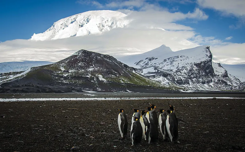
Heard is rugged and mountainous, 80% covered by compacted snow and small glaciers that form the island’s coastline. It represents the overwater portion of the formerly also submarine volcano Kerguelen Submarine Plateau.
The island is dominated by the Big Ben mountain range with its highest peak, the volcanic Mawson Peak. The volcano is covered with glaciers that descend to the sea with steep cliffs 15-30 meters high. Mawson is the highest peak in the Commonwealth of Australia. This nearly three-kilometer peak is higher than the 2,228-meter-high Kosciuszko Mountain, the highest point in mainland Australia.
Mawson is one of only two active volcanoes in the Commonwealth of Australia and the entire Antarctic zone.
The second volcano is located on the small and rocky McDonald Island, 43.5 km west of Heard. In 1992 it broke its long silence and began erupting, doubling its area (from 1 to 2.5 km2), increasing its height and completely destroying vegetation.
Since then, eruptions on McDonald occur from time to time, most recently in 2005. The highest point of the island is a small plateau with a glacier with a total height of 230 meters above sea level. The plateau is surrounded by steep cliffs descending to the coast and consists of the northern plateau and the southern steep Maxwell Hill.
The islands are located in the zone of sub-Antarctic climate, here it is windy and cloudy all year round, in the fall-winter period it may rain or snow for a long time.
Other land areas of the archipelago are many small remote islets, rocks and reefs, the largest of which are the Shag Islands, 10 kilometers north of Herd, as well as Flat Island and Meyer Rock, located south of McDonald.
The islands were inscribed as a UNESCO World Heritage Site in 1987.
This Australian archipelago includes territorial waters 12 miles from the shore line of each island.
The abundance of animals, pristine nature and unique landscape of the islands attract numerous tourists. There are no mooring facilities on shore, liners anchor off the coast and tourists view the islands from on board: landing on shore is strictly prohibited.
The islands are named after their discoverers. American Captain John Heard discovered the archipelago on November 25, 1853 while his ship Oriental was sailing from Boston to Melbourne, and the main island was named after him.
The second largest island was discovered on January 4, 1854 by the captain of the British ship Semarang, William MacDonald, and was named after him.
Until the 1880s, the islands were visited quite often, but interest in them disappeared, as it was too expensive to export the captured animals from here, and the population of seals was practically exterminated.
From 1910 the islands were considered a British colonial possession until they were handed over to Australia in 1947.
Nature of the islands
One of the permanent residents of Heard Island are king penguins. They share the rocky island with a colony of sea lions and huge bird bazaars where gulls and petrels nest.
Despite the harshness of the climate, Heard, McDonald and the surrounding small islets are nesting grounds for seabirds and rookeries of marine animals typical of the sub-Antarctic belt. Sea pigeons, frigates and albatrosses nest on the cliffs and coastline, as do king and emperor penguins and the world’s largest colony of golden-haired penguin. There are hundreds and hundreds of thousands of birds here, especially on Exile and Franklin Rocks on the south shore of Heard Island. Massive concentrations of elephant seals and birds appear in the summer season on the snow- and ice-free areas of Herd Island – Elephant-Spit Peninsula, on the shores of Winston and Manning lagoons, and on Gotley Glacier.
Due to the remoteness of the islands, the nature of these places is almost untouched by man. There is not a single introduced (alien, imported) species of living organism here. Coastal commercial fishing is allowed in limited amounts.
The only building on Heard Island is the abandoned research station Anare Station, used in 1947-1954 by the Australian National Antarctic Research Expedition.
General Information
- Location: South Indian Ocean.
- Administration: Australian Outer Territories.
- Main islands: Heard and McDonald.
- Origin: Volcanic.
- Heard Island: area – 368 km2, length – 43 km, width – 21 km.
- McDonald Island: area – 2.5 km2.
- Population: uninhabited islands.
- Highest point: 2745 m, Mawson Volcano (Heard Island, Big Ben massif).
- Minimum altitude: 0 m, Indian Ocean.
- Length of coastline: 101.9 km.
- Remoteness: 4099 km south-west of Perth (Australia), 4200 km south-east of South Africa, 3830 km south-east of Madagascar island, 1630 km north of the coast of Antarctica.
Climate and weather
- Subantarctic maritime.
- Mild winter, cold summer.
- Average temperature in January: +0.1°С
- Average temperature in July: +4.2°С.
- Average water temperature: +3.5°C.
- Average annual precipitation: up to 1900 mm.
- Average annual relative humidity: 80%.
Attractions
- Natural: Exile and Franklin Cliffs, Elephant Spit Peninsula, Winston and Manning lagoons, Gotley Glacier, Cape Pillar and Meyer Rock (Heard Island), bird markets, marine animal rookeries, volcanic landscapes, caves.
- Historical: Remains of a seal hunters’ settlement (second half of the 19th century), abandoned research station Anare Station (1947-1954).
Fun facts
- Despite the fact that the islands are uninhabited, a national top-level domain – .hm – has been allocated for them on the Internet.
- The glaciers of Heard Island are small and can melt very quickly, reacting to the slightest changes in climate – faster than other glaciers in the world. They therefore play a very important role in tracking climate change. The glaciers have shrunk considerably in recent decades.
- The nearest landmass to the Heard and McDonald Islands is Kerguelen Island, part of the French Southern and Antarctic Territories, 450 kilometers to the northwest.
- Mawson Volcano on Heard Island holds another record: it is the only known permanently active volcano in the subarctic region of the earth. As for the McDonald volcano, it “woke up” relatively recently, coming out of a dormant state that lasted about 75 thousand years.
- The relatively late discovery of the islands is explained by the fact that they are located in the latitude of the “furious fifties”, located between the “roaring forties” and “howling sixties”. The conditions here are exceptionally unfavorable for sailing vessels, and there is always a strong westerly wind.
- Since the discovery of Heard Island in 1855, people have landed on it about 240 times. And on McDonald has been set foot only twice: in 1971 and 1980, scientists – geographers and geologists, no more than 50 people visited the island.
- Preserved postal items from Heard Island are of great value for collectors, when there was a post office there in 1940-1950s, during the period of work of the Australian Antarctic research expedition.
- From an Australian perspective, Mawson Volcano is not Australia’s highest peak, but the second highest. Its inhabitants consider Australia’s highest mountain to be Mount McClintock (3,490 meters), located in Antarctica, in the Australian Antarctic Territory, as they call the sector of Antarctica claimed by Australia.


