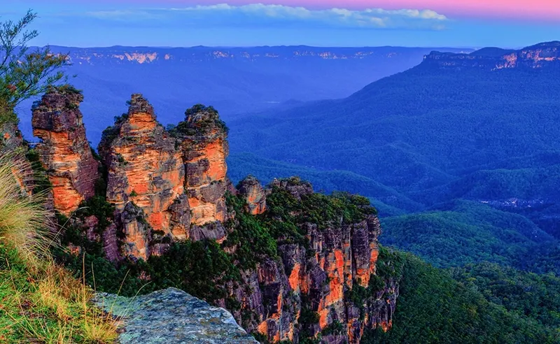
The Blue Mountains National Park gives the impression of a fairyland. And not only because of the eternal fog over them, but also because the landscape here is millions and millions of years old. Since the length of each meridian is 20,004,276 km, the Great Dividing Range occupies almost a fifth of its length.
The location of the Great Dividing Range between the Pacific Ocean coast and the interior of Australia is a major factor in shaping the climate of the entire continent.
Australia’s Mountain Wall
The Great Dividing Range is a massive north-south mountain system stretching about 3,500 km along Australia’s east and south-east coasts, from Cape York Peninsula in the north to Bass Strait in the south.
There are marked differences between the different sections of the range.
The eastern slopes are steep and deeply dissected. The western slopes are gentle, with fertile, hilly foothills called Darling Downs.
The northern part is an area of low mountains, volcanic plateaus and coastal ridges up to 1,000 meters high, interspersed with wide depressions; in this place the width of the ridge reaches 650 km. In the northernmost parts of the range, on the Cape York Peninsula, there are gentle uplands with individual ridges.
In the center, in the state of Queensland, the mountains become wider and their height increases, rising to 1600 m.
The southern part is the area where the Great Dividing Range reaches its maximum width of about 1500 km. Here it is split into separate mountain ranges of New England, Hastings, Liverpool, the Blue Mountains and the Australian Alps with the highest peak of the range and the entire continent – Mount Kosciusko.
In the far southeast the Great Dividing Range loses its meridional direction and extends from east to west along the latitudinal faults in the Earth’s crust which separated Tasmania from the mainland and which formed Bass Strait 60-100 million years ago.
The Great Dividing Range began to form about 300-500 million years ago and took its current shape about 25 million years ago.
The Great Dividing Range stretches in the meridional direction for thousands of kilometers, and therefore is located in a zone of three climatic belts – subequatorial, tropical (most of them) and subtropical. In each of them landscapes of windward eastern (wet) and leeward western (dry) slopes sharply differ. In the Australian Alps snow lies half the year.
It is on the western slopes of the Great Dividing Range where Australia’s largest river, the Murray, and its right tributary, the Darling, the continent’s second most important river, originate. It is also where the Creeks (periodically drying rivers) of Inland Australia begin: without a permanent channel, existing only during the rainy season. From the eastern slopes of the ridge flow into the Coral and Tasman Sea short rapids, but full-flowing rivers, navigable in their lower reaches, such as the Berdekin, Fitzroy and Hunter. The Great Dividing Range is so called because the rivers on the eastern slopes belong mainly to the Pacific Ocean basin, and those on the western slopes to the Indian Ocean and the drainless basin.
There is a very great difference in the nature of the leeward and leeward slopes. Windward slopes, facing the Pacific Ocean and receiving humid air masses from it with trade winds, are covered with deciduous evergreen and eucalyptus forests. The Blue Mountains and their surroundings are a UNESCO World Heritage Site for the evolutionary development and diversity of Australia’s eucalypt forests.
The leeward areas, which no longer receive as much moisture, are drier, covered with sparse forests, savannas, and thickets of xerophytic shrubs.
The forests of the Great Dividing Range are home to all the animals typical of Australia – the koala, the couscous, the tree kangaroo – and birds – the paradise bird, the lira bird, the cassowaries, and parrots.
The location of the Great Dividing Range between the Pacific Ocean coast and the interior of Australia is a major factor in shaping the climate of the entire continent.
High mountains, deep gorges, amazing fauna and flora of the Great Dividing Range gave birth to many legends, including relatively recent, during the colonization of Australia.
Thousands of years before British colonization of Australia, the Great Dividing Range was inhabited by many Aboriginal tribes. They paved trails in the mountains, found the best parking places, which people use even today. The natives of the continent lived in caves, on the walls of which they left drawings and mysterious signs, probably having to do with aboriginal cults.
The high, mighty mountains inspired awe and reverence, if not terror, in the Aborigines. For example, Gundungur folklore tells of the creation of the Blue Mountains in times immemorial by creatures called Mirigan and Garangat, half fish, half reptile. The monsters came together in a grand battle, smashing everything around them, and so the mountains and valleys came into being.
The Gandangara tribe carried through the millennia the belief in humans with the appearance of animals called burringlings, hiding in mountain caves and also capable of changing the surrounding landscape.
The European settlers were greatly impressed by these mountains, mainly because it took a long time for them to find passages and passes to get to the opposite sides of the mountains. When they landed on the coast of the Pacific, they had long been convinced that vast fertile lands awaited them beyond the mountains to the west, but they saw not only green plains, but also the scorched surface of endless deserts. And among the convicts brought to the continent, there was even a legend that right behind the mountains was China, where one could escape if he could find an underground passage in the mountains.
The real wealth of the ridge is its subsoil. In the central part of the ridge is the Sidney-Bowen Marginal Trough, filled with sedimentary rocks. Oil and gas deposits have been found there, hard coal and lignite in the south, and large metal ore deposits throughout the range.
In the area of the Great Dividing Range are a few major cities, including the capital of Australia, Canberra, which stands near the Brindabella Mountains at an altitude of 700 m. But mostly small towns with a population of a few thousand people, nestled in the intermountain valleys. Many in the 19th century were bustling mining centers, mostly gold, and lawlessness reigned in them. Today they are not even cities, but quiet villages serving the needs of cattle farmers, hunters, and tourists. An exception is Kilsit in the Dandenong Mountains: as neighboring Melbourne has sprawled, it has become a suburb of Melbourne.
Perhaps the greatest danger to the people and nature of the mountains is the frequent wildfires. Fires come to the mountains from the bush, the foothills overgrown with brush and stunted trees. If the heat is intense and the plants are dry, there is no way to stop the bush fire, spurred on by winds of 120 kilometers per hour. The flames begin to climb up the mountain slopes, reaching almost to the tops and destroying all life. The fire can burn for a month and only stop when the weather changes. The only way to reduce the risk of fire is through a government program to burn certain areas of forest on the mountain slopes to keep the fire from spreading higher.
General Information
- Location: Eastern and south-eastern Australia.
- Administrative location: the states of New South Wales, Queensland and Victoria.
- Mountain ranges: New England, McPherson, Hastings, Liverpool, Blue Mountains, Australian Alps, McElreath, Iron Range, Warroombangle, Brindabella.
- Cities: Canberra – 381,488 (2013), Toowoomba – 113,625 (2014), Ballarat – 98,543 (2014), Kabultur – 59,052 (2011), Bathurst – 41,682 (2014), Orange – 39,766 (2014).
- Languages: English, Aboriginal.
- Ethnicity: Australians – descendants of migrants, indigenous Aboriginal people (Bamaga, Seesia, Darug, Gandangara, Vodi-Vodi, Ngunawal).
- Religions: Protestantism, Catholicism, animism.
- Currency unit: Australian dollar.
- The largest rivers are Murray with a tributary Darling, Berdekin, Fitzroy, Hunter.
Figures - Area: 2,456,547 km2.
- Length: about 3,500 km.
- Maximum width: 1568 km.
- Highest point: 2228 m (Kosciuszko, the Australian Alps).
- Other peaks: 2209 m (Townsend, the Australian Alps), 1913 m (Bimberi, the Australian Alps), 1857 m (Ginger, the Australian Alps), 1372 m (Oxley, Liverpool), 1362 m (Bindo, the Blue Mountains), 1372 m (Barney, McPherson), 1177 m (Lindsey, McPherson).
Climate and weather
- Subequatorial, tropical and subtropical.
- The average January temperature is +26°C in the north and +21°C in the south.
- The average temperature in July is +17°C in the north and +5°C in the south.
- Average annual rainfall: 1000 to 2000 mm on the eastern slopes and 200 to 700 mm on the western slopes.
- The relative humidity is 75-80% on the western slopes and 65% on the eastern slopes.
Economy
- Minerals: oil and gas (Roma), coal (Newcastle and Wollongong) and lignite (Melbourne), tin (Mount Garnet), gold (Charters Towers), copper (Mount Morgan), titanium-magnetite and monazite sands (Byron Bay, Ballina), polymetals (Herberton).
- Scope of services: tourist, transport, trade.
Attractions
Natural
- Black Mountains, Kosciusko, Mount Buffalo, Jardine River, Wallamie, Blue Mountains, Kula Tope and Lakefield National Parks, Pandora Pass (788 m), Teviot Falls, Queen Mary, Duggs and Browns, Jenola Caves, Brindabella Valley.
Historical
- Aboriginal petroglyphs (Jibbon Point), ancient drawings (Blue Mountains, Hands Cave, 22,000 years old), Australia’s oldest Lennox Bridge (1833), Lapstone Zig-Zag Railway and Napsack Viaduct (1863-1865), Puffing Billy narrow-gauge railroad (Puffing Billy, 1900).
Fun Facts
- The Great Dividing Range is the third longest on Earth, after the American Andes (7,000 km) and the Rocky Mountains (4,830 km). Sometimes it is put in fourth place, if the first place is given to the mid-oceanic ridge at the bottom of the World Ocean, whose total length according to various estimates – from 40 to 70 thousand km.
- The mountains of Liverpool are not directly related to the English city. They received their name in honor of Robert Jenkinson, the 2nd Lord of Liverpool, who was British prime minister in 1812-1827 when European settlers first began to explore this part of Australia.
- Pandora Pass on the Warroomangle Ranges was discovered in 1823 by the English botanist and Australian explorer Allan Cunningham (1791-1839). Before him, this section of the Great Dividing Range was considered impassable, making it difficult for settlers to communicate on the eastern and western slopes. Canningham recounted that the name of the pass came into its own when there was only hope of finding it in one place. The ancient Greek myth of Pandora tells us that when she opened the box that contained all the evil of the world, it immediately scattered in all directions, and only hope remained at the bottom.
- The steepness of the slopes of the Great Dividing Range is demonstrated by the reconstructed old Katumba Mountain Railroad in the Blue Mountains. It is the steepest railroad in the world in terms of grade: 50.7′. It is 415 m long and used to haul coal and shale mined in the mountain basin.
- The Blue Mountains in New South Wales were given their name from a puff of blue mist, caused by fumes from the eucalyptus trees, which turn the mountains blue.
- While the exact elevation of Mount Kosciuszko (2228m) in the Australian Alps was unknown, the nearby Mount Townsend (2209m) was thought to be the highest on the continent. It was this mountain that the Polish traveller, geographer, and geologist Pawel Edmund Strzelecki (1797-1873) had climbed, naming Kosciuszko after the Polish national hero Tadeusz Kościuszko (1746-1817). When the truth was established, out of respect for Strzelecki, the state authorities in New South Wales simply changed the names of the two mountains so that the highest one was still called Kosciuszko. Climbers have developed a tradition: since the ascent of Mount Townsend is much harder than that of Kosciuszko, each climber takes a stone at the foot of the mountain and leaves it at the top so that over time it becomes higher than Mount Kosciuszko.
- In the 1860s there was a need for a railroad through the Blue Mountains, but the British colony of New South Wales did not have the money to tunnel a 3-kilometer tunnel through the mountains. To get around the obstacle, they built the road on the principle of a zig-zag: the tracks looped across the mountainsides until they reached the right height. Today, the railroad is closed, but it has become a popular tourist route.
- The Australian Alps are not as high and impregnable as their European and New Zealand Southern Alps: most peaks can be climbed without special climbing equipment.


