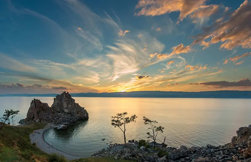
Baikal is the world’s largest reservoir of drinking water, the deepest depression in the continental crust and the deepest lake on Earth. Its water has unique properties, and most of the organisms inhabiting the lake and its surroundings are found nowhere else.
This legendary lake is a unique creation of nature. In 1996, Baikal was included in the list of UNESCO World Heritage Sites.
The deepest lake in the world
The salt content of Baikal water is so low (only about 100 mg/l) that it can be used as distilled water. There are several reasons for this. The mountains from which the streams and rivers that feed Baikal flow into the lake are composed of poorly dissolving volcanic crystalline rocks. Therefore, the water flowing into the lake contains few mineral impurities. The microscopic crustacean Epishura, which makes up about 80% of the total biomass of lake zooplankton, successfully copes with organic impurities. It not only purifies water, but also serves as an important part of the food chain of the Baikal biosphere. Epishura is a Baikal endemic, i.e. it is not found anywhere except Lake Baikal. In general, 2/3 of the 2630 animal and plant species known to science that inhabit Lake Baikal are endemics. Among them are not only crustaceans, sponges and insects, but also fish, such as holomyanka and omul, and even the seal – Baikal seal. Endemics are also 60 species of plants growing on the shores of the lake. Due to the huge water mass of Lake Baikal, which slowly warms up in summer and just as slowly cools down in autumn, the climate on the shores of the lake is more temperate than in neighboring areas of Western Siberia. However, this is also the reason for the famous Baikal winds, each of which has its own name – Barguzin, Verkhovik, Kultuk, etc. (more than 30 in total). (more than 30 in total).
Baikal is the oldest lake in the world. Scientists estimate its age at 25-35 million years, but it is not only not aging, but is constantly renewed. The outlines of the lake shores change not only as a result of tectonic activity, but also due to a number of other factors.
About 25 million years ago, shallow lakes existed in the Baikal area – the remains of a huge ancient extinct sea. Later, there were repeated intensive tectonic movements of the Earth’s crust, accompanied by faults and faults, volcanic activity and earthquakes. Mountain ranges appeared in Pribaikalie, and the hollows between them were filled with water at the beginning of the Quaternary period. While other lakes age, silt up and disappear with time, Baikal, on the contrary, still retains its youthfulness – its water surface and depth continue to increase. Tectonic processes around Baikal are taking place even now. During the earthquake in January 1862 a part of the Selenga River delta went under water – at this place a Proval was formed – a new backwater of the lake with the depth of 5-7 meters. In recent decades, the village of Ust-Barguzin, which stands on the shore of the lake, had to be moved twice to avoid flooding by the advancing waters of Lake Baikal. The rejuvenation of the lake is caused by three interrelated factors: tectonic movements, erosion of the shores, and pressure of loose sediments and water on the bottom.
Due to tectonic movements, the area of the lake mirror increases by 600 m2 on average per year, and the volume of the water body – by 400 thousand m3.
The erosion of the shores also leads to the increase of the lake mirror, and its bottom continuously sinks under the action of the gravity of loose sediments and the water mass of the lake itself. Sprawling of the lake due to retreating shores leads to increased wave action, which in turn activates the scouring processes. Therefore, the outlines of the Baikal shoreline are constantly changing. There are 22 islands on the lake, the largest of which is Olkhon (73 km long and 11 km wide). The name of the island translates from Buryat as “dry”. Indeed, rains on the island are very rare. According to local legends, Olkhon is home to the formidable spirits of Baikal.
General information
- A lake in the south of Eastern Siberia.
- Two subjects of the Russian Federation – the Republic of Buryatia and the Irkutsk Oblast – are located on the shores of Lake Baikal.
- There are three large nature reserves, three national parks and a number of smaller nature reserves and natural monuments in the Baikal area.
- In 1966, a pulp and paper mill was built on the shore of Lake Baikal, and its wastewater flowed into the lake. In addition, timber was delivered to the mill via the lake, and sunken logs were another source of pollution. The struggle of scientists against the pulp and paper mill started actually before it was built, but the production was stopped only at the end of 2008.
- Basin area: more than 550 thousand km2.
- Age: 25-35 million years.
- Length: 636 km.
- Width: from 25 to 79 km.
- Average depth: 730 m.
- Maximum depth: 1637 m.
Climate and weather
- The climate of Eastern Siberia is sharply continental. However, elements of a milder maritime climate appear on the Baikal coast due to the huge mass of water.
- The average temperature in January is -17ºС and in July +16ºС.
- The warmest place on Baikal: Peschanaya Bay.
- Average annual temperature: +0.4ºС.
Attractions
- Reserves: Barguzinsky, Baikalsky and Baikal-Lensky.
- Pribaikalsky and Transbaikalsky National Parks.
- Historic Circum-Baikal railroad built in 1904.
- Baikal seal rookeries on the Ushkan Islands.
Fun Facts
- The catchment area of Lake Baikal is over 550 thousand km2, which is comparable to the area of France.
- There are 336 rivers flowing into Lake Baikal, and only one river – Angara – flows out of it, which carries up to 85% of the total annual runoff into the lake.
- The surface area of the lake is 31.5 thousand km2. This makes it the sixth largest lake on the planet. In terms of volume, it is unrivaled among freshwater lakes. To fill the Baikal basin would require the total flow of all the rivers of the world in 230 days.
- Lake Baikal contains 22% of all unfrozen fresh water on Earth.
- Baikal surpasses the Black Sea in the number of storm days. Each region of the lake has its own local winds.