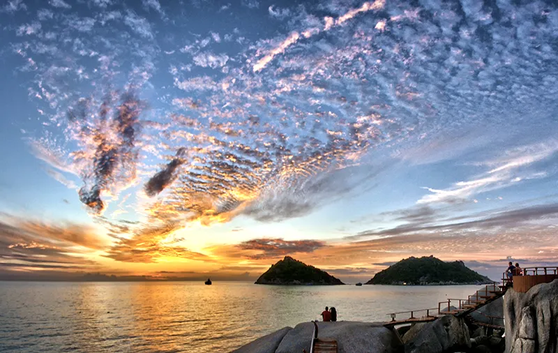
The Gulf of Thailand is a part of the Pacific Ocean located in southeast Asia, between the Indochina Peninsula and the Malay Archipelago. It washes the shores of Thailand, Cambodia, Vietnam and Malaysia.
The Gulf of Thailand was named after the former kingdom of Siam, now known as Thailand. The bay has an area of about 320 thousand square kilometers and is one of the deepest bays in the world.
The Gulf of Thailand is home to many natural phenomena such as tides, tsunamis and hurricanes. The Gulf is also rich in marine resources such as fish, shrimp, squid, and other seafood, making it an important source of income for the fishing communities along its shores.
Geography
The Gulf of Thailand is the westernmost region of the semi-enclosed South China Sea. The gulf forms a depression of considerable size on the southern coast of Southeast Asia, between the Malacca Peninsula to the west and Indochina to the east.
The Gulf of Thailand coastline is usually delineated from Cape Bai Bung in the east of Vietnam to the southwest around Kota Baru in Malaysia, near where the Kelantan River flows into the South China Sea.
To the south and southeast, the Gulf of Thailand crosses into the South China Sea. The International Hydrographic Organization defines this boundary of the Gulf of Thailand as the line between Cape Camau in Vietnam and the Kelantan River estuary.
The Menam-Chao Praya, Bangpakong, and Mekong rivers flow into the Gulf of Thailand. In addition to these rivers, another large river flows into the bay – the Tapi, the longest river in southern Thailand, whose mouth is near the Thai city of Surat Thani.
Scattered throughout the gulf are small islets, which are mostly extensions of mountain ranges, deepening into the sea. In other words, the islands of the Gulf of Thailand are located within the underwater margin of the continent, formed by indigenous rocks and belong to the continental.
One of the most famous islands in the gulf is Takyu (Be) belongs to Cambodia and is located next to the Cambodian National Park Ream (one of the seven national parks of Cambodia). It is home to endangered bird species: the Brama kite, gray-headed and white-bellied sea eagle, Javanese marabou, milkvetch, Indian beaked whale and collared alcyon.
Unlike other bays of Southeast Asia, the Gulf of Thailand is not deep at all, and its maximum depth does not reach even a hundred meters. The bottom of the bay at great depths is covered with bottom sediments of silt and sand, but in shallow water, near the coast of the islands, the ground is usually rocky, covered with corals that have grown on the rock base for many thousands of years.
The entire area of the bay is a monsoon area, which begins and ends there earlier than in any other part of the South China Sea. Due to the shallow depth and proximity to the equator (the Gulf of Thailand is located approximately between 15°N and 8°S) the water is very warm, and its temperature often rises above 30°C).
History
The history of exploration of these areas is rather confusing. Numerous empires and peoples have appeared and disappeared here, administrative boundaries were erased and established again causing confusion and mutual claims. This is why the borders between the Gulf of Thailand countries are still the subject of territorial disputes between Malaysia, Thailand, Cambodia and Vietnam to this day. Most of the territorial disputes concern ownership of individual islands and portions of the continental shelf where oil and natural gas deposits have been found.
Economy
Fish, oil, ferries and resorts are the main assets of the Gulf of Thailand.
The biological resources of the Gulf of Thailand are enormous, despite intensive fishing. The most popular commercial fisheries are tuna, herring, sardine, mackerel, and mackerel. Sea fish is caught by large fishing boats and exported mainly in dried and salted form. At the end of the 20th century, the Gulf of Thailand was one of the top ten seafood producing countries in the world, catching millions of tons.
As for most local fishermen, they do not have such ships due to poverty, and they hand-pick crabs, shrimp and edible clams – mussels and oysters: a night’s catch can be up to three kilograms. The most common fish here is the mullet, which lives in the lagoons or deltas of the rivers.
The ichthyofauna has formed along the shores of the bay, in the mangroves, in the conditions of complete drying out of water reservoirs, the widespread marshes and high humidity. These species have adapted to crawl out of the water on the roots of trees and stay for a long time in the air, feeding on ground insects. Other species can burrow into the mud and wait out the dry season there.
The main occupation of most coastal residents is the extraction of seafood, including a variety of edible algae.
Many small fishing villages are scattered along the coast, consisting of houses built in the middle of the mangroves on stilts, because the tides here are rather high.
In addition to the Gulf of Thailand itself, fishing is done in the deltas of the rivers flowing into it. Carp, gobies, perch, and eels abound here. Almost the entire catch is used for food in the Gulf of Thailand because fish, like rice, is the staple food of the people.
There is oil and gas production all over the Gulf of Thailand, offshore and around the islands, but it is still quite small.
A more important branch of the local economy is shipping in the Gulf of Thailand. Most of it is done with the help of huge sea ferries, capable of carrying two thousand people each. Because of the harsh climate and typhoons that periodically rage in the Gulf, the ferries-usually overloaded ones-have had disasters with many victims. Drift currents form in the South China Sea under the influence of the monsoon.
The largest port in the gulf is Bangkok: its cargo turnover is about 18.5 million tons.
One of the most important income sources of the Gulf of Thailand is tourism and resorts.
Long gone are the days when Pattaya was a fishing village. Today it is one of the leading resorts in the world, with a perfect infrastructure and service system for every taste, even the most unusual. The locals were able to use the sunken ships at the bottom of the bay, organizing scuba diving tours and showing the remains of ships from different times – from wooden Chinese junks to armored warships of World War II.
The resort area also includes the islands of Samui, Phangan, Tao, and Chang, which are major tourist centers nestled in the middle of coral reefs.
General Information
- Location: Southeast Asia, between the Malacca Peninsula and southeast Indochina.
- The largest rivers flowing into the bay are the Mekong, the Chao Phraya (Menam-Chao Phraya), the Bangpakong Thali.
- Major ports: Ratzya (Vietnam), Psar-Ream, Kep, Kampot (Cambodia), Bangkok, Pakphanang Pattani, Chonburi, Sonkla, Chanthaburi (Thailand).
- Coastal states: Kingdom of Thailand to the west and north. The Kingdom of Cambodia and the Socialist Republic of Vietnam to the east, and Malaysia to the southwest.
- The largest islands are Phu Quoc (Vietnam), Ream, Kong Rong (Cambodia), Samui, Phangan, Tao, Samet and Chang (Thailand).
- Area: 320,000 km2.
- Width at the entrance: about 400 km.
- Length: 720 km.
- Maximum depth: 84 m.
- Average depth: 45 m.
- Average salinity: 31%.
- Average water temperature: +28 – +29°C.
- Tides: Daily, up to 4 m.
Finance
- Minerals: oil, natural gas, tin.
- Industries: shipbuilding, food.
- Agriculture: plant growing (coconuts).
- Fishing.
- Services: tourism, transport, trade.
Climate and weather
- Humid tropical.
- Average temperature in January: +27°C.
- Average temperature in July: +29°C.
- Average annual rainfall: 1500 mm.
- Southwest monsoon in July, northwest monsoon in November.
- Typhoons.
Attractions
- Butterfly Park Na Tian (Samui Island, Thailand).
- Landmarks: Wat Ninh Ngu Temple (Koh Samui, Thailand).
- Moo-Ko-Ang-Thong Marine Park (Thailand).
- Fish port Chumphon (Thailand).
- Islands: Phu Quoc (Vietnam), Samui, Samet, Phangan, Tao and Chang (Thailand).
- City of Kota Baru (Malaysia): Old royal palace.
- City of Bangkok: Wat Pho Monastery (Temple of the Lying Buddha, 12th century), Wat Phra Keo Monastery and a statue of the Emerald Buddha (15th century), Dusit Maha Prasat (Heavenly Palace), Wat Ratchanadda Temple (19th century).
- Phetchaburi City: Nakhon Khiri Historic Park and the Palace, the former royal summer residence.
- Chanthaburi City: Immaculate Conception Cathedral, the largest Roman Catholic Church in Thailand.
- Chonburi City: Khao Sam Muk Hill.
- National parks: Samet (Thailand), Ream (Cambodia).
Fun Facts
- Thailand’s Mu-Ko-Ang-Thong National Marine Park consists of 42 small islands. The nature and landscape of the islands have been preserved in an almost pristine condition largely due to the fact that the area was long owned by the Royal Thai Armed Forces and closed to the public, and after 1980 it was listed as a national park.
- Samet National Park (full name – Khao Lem Ya – Samet) has very unusual fauna. Among them: flying fox – a genus of meandering wings of the family, which eats the sap and pulp of fruits and flowers, 40-centimeter creature with a fox head, sea bream, which can swim far into the sea, and bullfrog – one of the largest species in the family of true frogs, reaching a length of 25 cm. Bullfrog got its nickname not for its size, but because to attract females, the males emit very loud call sounds, reminiscent of mooing.
- Phu Quoc is the largest island in Vietnam. Located on it the Phu Quoc airport now transports mainly tourists. It was established in the 1930s, during the French colonization of Indochina, and in the mid-20th century was the site of the U.S. Air Force base during the Vietnam War 1960-1970s.
- Because of the continued deposition of river silt and sand the coastline of central Thailand is moving farther and farther south the water depth is only 11 m at a distance of 10 to 20 km from the shore. Coral reefs are the first to suffer because of the harmful effects of warming water. The opposite process is occurring in the Mekong Delta: the sea is encroaching on the land, salinizing the soil and destroying entire villages in large-scale landslides. Global climate change is to blame, and the delta will become the most vulnerable place if the water level rises as a result of warming.


