The Zambezi is a river in South Africa, one of the continent’s largest rivers. The Zambezi is about 2,700 kilometers long and flows through six countries: Zambia, Angola, Namibia, Botswana, Zimbabwe, and Mozambique.
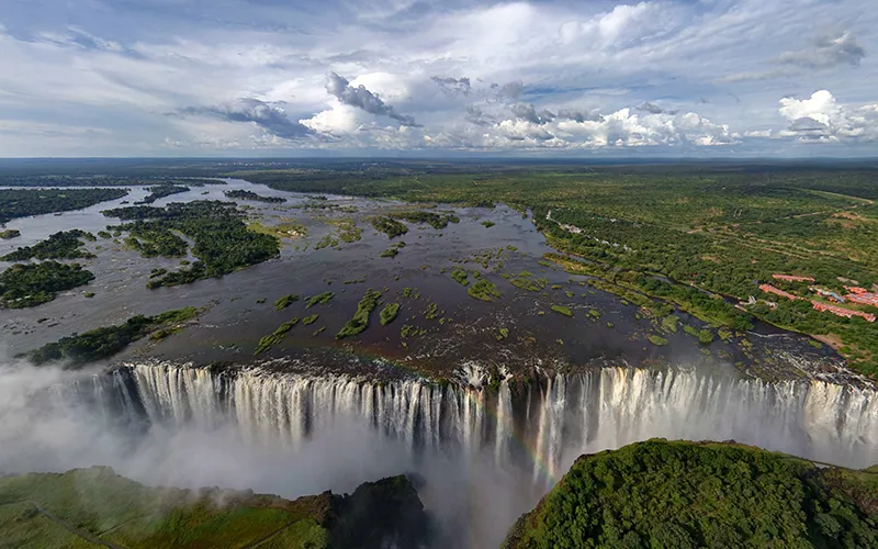
The Zambezi is one of the most famous rivers in the world because of the Victorian Falls, which are located on the border of Zambia and Zimbabwe.
The Zambezi is of great importance to the region because it provides water for irrigation and agriculture along its basin. The river is also used for power generation through the construction of the Kariba Hydroelectric Power Plant.
The Zambezi is also popular with tourists who come to see the Victorian Falls and engage in water sports such as rafting and kayaking.
Geography and History
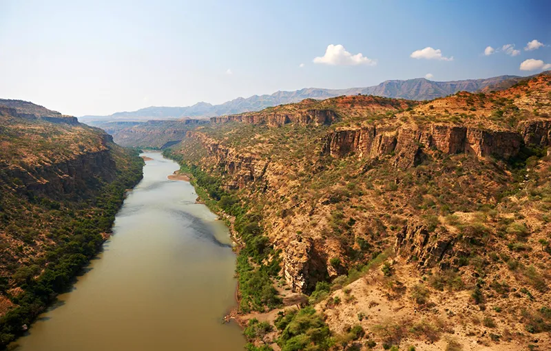
The Zambezi is one of Africa’s four great rivers after the Nile, Congo (Zaire), and Niger. The Zambezi is born in a swampy area in northern Zambia, on the Lunda Plateau at an altitude of 1,500 m, rushes southwest and after about 240 km makes a gentle turn to the south, taking in small rivers and fed by groundwater along the way. All the way upstream, dense deciduous forests, like faithful guards, accompany it. Having left them on the territory of Angola, further the Zambezi flows among the tall grass savannah and miombo dry light forest: trees in it stand at a considerable distance from each other, low bushes and vines grow between them. At the Chavuma Falls the Zambezi, having passed through the rapids, returns to Zambia. The height of the plateau here is already about 1100 m, and the width of the river is more than 350 m (in the rainy season). From the Chavuma Falls to the Ngwambe Falls the Zambezi takes the major tributaries Kabombo and Lungwebungd, and the Barotse floodplain begins, and after another 30 km the Zambezi shores become flat, the current here slows down and turns to the southeast. The Luanjinga River flows into the Zambezi from the west 80km downstream. The Barotse in the rainy season floods and then the Zambezi can be up to 25 km wide. Below this is a series of rapids and rapids, culminating in Ngonje Falls. This section of the Zambezi is navigable. After it the full-flowing Kwando (Chobe) River joins the Zambezi. It marks the border between Angola and Zambia, then the short border with Namibia, the end of that country’s narrow corridor wedged between Angola. Botswana and Zimbabwe back in 1891 by treaty between the British Cape Colony and the German protectorate of German Southwest Africa. As it joins the Kwando, the Zambezi flows at an altitude of 920 meters above sea level, turns eastward and slows as if it is preparing to collapse into Victoria Falls, its most famous natural treasure, powerful and beautiful.
The falls, called Mosioatunya (“the rumbling smoke”) by the natives, were the first thing Europeans saw when David Livingstone (1813-73), the famous African explorer. He saw it on November 17, 1855, while traveling along the Zambezi.
He gave the waterfall the name of the British queen. And he wrote of it as follows: “The spot so beautiful must have been looked upon by angels in flight.” Victoria Falls are about 1800 meters wide and have a drop height from 80 to 108 meters, during the rainy season it throws down 9100 m3 of water per second. The spray and fog over the falling stream rises to 400 m and higher. The sound can be heard 30 km away, hence the “rumbling smoke”. The next 200 km the Zambezi flows between 200-250 m high hills and 20-60 m high basalt rocks, speeding up in the rapids and chutes. Another attraction and the main hydraulic structure on the Zambezi is the Kariba Dam and its reservoir, created in 1959 in the Caribbean Gorge. The Itezhi-Tezhi Dam on the Kafue River, the largest left tributary in the middle reaches of the Zambezi, adds its share of power. At the confluence of the next left tributary, the Luangwa, the Zambezi’s path through Mozambique begins – 650 kilometers – and they are navigable. Here is another major hydroelectric structure, the Cahora Bassa Dam and Reservoir, built in 1974. The width of the Zambezi in Mozambique is 5 to 8 km during the rainy season. Only 320 km from the mouth the Zambezi enters the Lupata Canyon gorge, which is no more than 200 m wide. The Shire River, which flows out of Lake Nyasa (Malawi), enters the Zambezi 160 km from its mouth. The largest arms of the delta, covered with mangrove forests, are Milaimbe, Kongone, Luabo and Timbw. But only one is navigable, the Schende, on which the only Zambezi port of the same name is located.
The upper and middle reaches of the river valley are in a climatic zone where the trade winds of the Northern and Southern Hemispheres converge. After several months of scorching heat in mid-November, the skies over the Zambezi are covered with heavy layers of thunderclouds, from which a wall of rain falls, and all wildlife rushes to the water, which on the plains spills in some places to a distance of 25 km, only small islands of land appear on the surface. From the interior of Central and Southern Africa, large herds of black and wildebeest, buffalo, zebra, lion pride, families of elephants and rhinoceroses, countless flocks of spoonbills, herons, cranes and pelicans head here. They are accompanied by hyenas and hyena dogs. Monkeys move through the trees, among which the most numerous species are baboons. The shallow waters formed by the spill are teeming with juvenile fish, and herds of catfish rush there. From the Indian Ocean upstream, the gray bull shark, which can exist in both sea and fresh water, moves in. In some parts of the Zambezi, herds of hippos congregate at this time.
In full accordance with the laws of natural selection, life-and-death battles take place on the banks, watched closely by the phlegmatic crocodiles.
And then the drought comes again: the grass dries out, the small tributaries of the river dry up, there is almost no food for many species of animals, except for some roots, dried fruits of trees and leaves of succulents. The animals migrate to other places on the continent. But the Zambezi, even in this season of heat, will water all who remain.
Associated with the seasonal cycle is the colorful festival of the vine people who live in the Barotse floodplain, or Barotseland. It is called the Kuombok festival, which means “to get out of the river.” The lozi, led by their leader (litunga), set sail away from the flooded areas On the front boat is the king, who is taller than the litunga, the elephant, or rather his statue, and next to the statue of his “consort” in the form of a crane. The action is accompanied by loud drumming and singing. The Lozi are one of the most ancient peoples of the Bantu group, who settled in the lands near the Zambezi (but not only here) several thousand years ago. Another ancient people living near the Zambezi, between the Zambezi and Limpopo rivers and also belonging to the Bantu group, are the Shona. Their ancestral empire of Monomotapa (Mwene-Mutapa) emerged in the 6th century, flourished in the 13th-15th centuries and collapsed by the early 18th century as a result of internecine conflicts and wars with the southern Ndebele people. It was influential far beyond its borders, had such rich oral folklore and such a high culture of farming, metallurgy, ceramics and ornaments that some African researchers are inclined to consider Monomotapa even a separate civilization. The ruins of its capital, the fortress city of Great Zimbabwe, near the modern city of Masvingo in Zimbabwe is a monument of world significance. These are mainly the remains of giant towers built from blocks of granite and surrounded by powerful walls.
Even in the Zambezi Valley, which is almost free of the technogenic pressure of modern civilization, there is no escaping environmental problems. Reservoirs have made adjustments to the biological balance of the river: new species of aquatic plants and fish have appeared. The Caribbean reservoir is located in the earthquake zone, its water surface area is 5580 km2, and its depth is up to 97 m. Such a mass of water creates serious pressure on volcanic rocks, and it is believed to have caused at least eight recent earthquakes in the south of the continent. There is also the problem of pollution of the waters of the Zambezi by chemical runoff.
General Information
- The fourth longest river in Africa and the longest in Africa flowing into the Indian Ocean.
- Countries crossed by the river: Angola, Namibia, Botswana, Zambia, Zimbabwe and Mozambique.
- Feeding: by rain, in the upper reaches ground waters.
- Source: spring on the Lunda Plateau in northern Zambia, near the NDRC border.
- Mouth: Indian Ocean (Mozambique).
- Main tributaries: Lungwebungd, Kwando, Luangwinga, Kabombo, Kafue, Luangwa and Shire.
- The largest rapids: Katima, Kebrabasa.
- The largest waterfalls: Victoria, Chavuma, Ngonye.
- Zambezi population: about 32 million people.
- The largest populated areas along the banks: Mongu (Zambia), Katima-Mulilo (Namibia), Seshek (Zambia), Livingstone (Zambia), Victoria Fole (Zimbabwe), Kariba (Zimbabwe), Chemba (Mozambique).
- The largest reservoirs: Kariba, Cahora Bassa.
- The largest lake in the Zambezi basin: Nyasa (Malawi).
- Port: Chinde (Mozambique).
- Bridges: in Chingui, Katima-Mulilo, Victoria Falls, Chirundu, and Tete.
- The most important airport: at Livingstone, connected by daily flights with O.R. Tambo International Airport in Johannesburg (South Africa).
- Length: 2,574 km.
- Basin area: 1,570,000 km2.
- Maximum width: 1380 m (in the dry season) – before Victoria Falls.
- Average water flow rate at the mouth: 7000 m3/sec.
- Average annual flow: 220 km3
Climate and weather
- Equatorial, mild Three seasons: cold and dry from May to August (winter), hot and dry from September to November (spring), warm and humid from November to April (summer).
- The country’s average temperature ranges from +16°C to +27°C in cold months and from +27°C to +38°C in hot months.
- Average annual precipitation is 1100 to 1400 mm.
- Average annual evaporation: 1600-2300 mm.
- Floods in the rainy season: November-April.
- Highest water level: November.
Economy
- Hydropower: hydroelectric power plants of Kariba and Cahora Bassa.
- Agriculture: growing sorghum, maize, vegetables; cattle breeding.
- Shipping.
- Fishing and fish breeding.
- Services: tourism (Victoria Falls, rafting and kayaking on the Zambezi and its tributaries).
Attractions
- Waterfalls: Victoria Falls, one of the world’s greatest waterfalls (listed as a UNESCO Natural World Heritage Site), Chavuma Falls on the border of Zambia and Angola and Ngonye Falls in Zambia.
- The Zambezi Delta.
- Lake Kariba (Caribbean Reservoir) – as a recreation area.
- Ruins of the ancient city of Great Zimbabwe (UNESCO World Heritage Site).
- National Parks in the Zambezi Basin: Mana Pools (UNESCO World Heritage Site), Zambezi, Mosioatunya, Victoria Role, Cameo, Liuwa Plains, Liuwa Sioma Nguezi, Chobe, Hwange, Lower Zambezi.
- Crocodile Farm (Livingston).
Fun Facts
- The Zambezi has its own god Called Nyaminyami, he has the body of a snake and the head of a fish. He has the body of a snake and the head of a fish and is prayed to by the tribes who have long lived on the banks of the river not to become too restless when there is a flood. In 1957, the elders of the Batonka tribe living on the lower Zambezi, dissatisfied with the construction of the Kariba dam, asked for help from Nyaminyami, whom they believed the dam would separate from his wife. And that same year a great flood on the Zambezi, caused by an earthquake, brought torrents of water down on the dam. Oma survived, but many of her service buildings were destroyed.
- When David Livingstone arrived at Victoria Falls, he was accompanied by a detachment of 300 local warriors. But only two of them dared to approach the falls with the “mad Englishman.
- In the Zambezi River Valley, in the jungles of Zambia and Zimbabwe, in the Wadomo tribe, most people have only… two toes, and they’re both thumbs. Those who have such feet are also called “people ostriches” (“sapadi”). There are two scientists’ opinions about this anatomical anomaly. The first is some kind of virus. The second is a consequence of closely related marriages. But otherwise, these people are perfectly normal, and they can move very deftly through trees and run very fast.
- The Kariba Hydroelectric Power Plant supplies most of Zambia and Zimbabwe, the Cahora Bassa Hydroelectric Power Plant supplies the rest of Zimbabwe and South Africa with electricity. There is also a small power plant in the city of Victoria Fole.
- In 1975, the two warring parties in Southern Rhodesia (now Zimbabwe) were negotiating on the Victoria Bridge in a railroad car. For nine hours they argued, proving something to each other, but were too often distracted to admire the waterfall and never got anywhere.
- The women of the Batonka tribe look, to Europeans, very strange, but to the opinion of their tribesmen – they are perfect: in the name of beauty they have six front teeth removed, this procedure is performed by a special dentist of the tribe. In addition, to protect them from mosquitoes, they smear their faces and exposed body parts with red ochre.


